OFA steering group member Simon Collings was interviewed Monday 22 May for a BBC News report on a new flood resilience training centre which has opened at Wallingford. The BeFloodReady centre provides advice and training on how to make properties more resilient to flooding.
With flooding expected to increase as a result of climate change, household level preparedness will become increasingly important. Exceptionally heavy downpours of the kind we have already seen this year, can cause flash flooding in areas which have not flooded before. It is particularly in these areas where property level measures can help protect against flooding and facilitate quick recovery where flooding does occur.
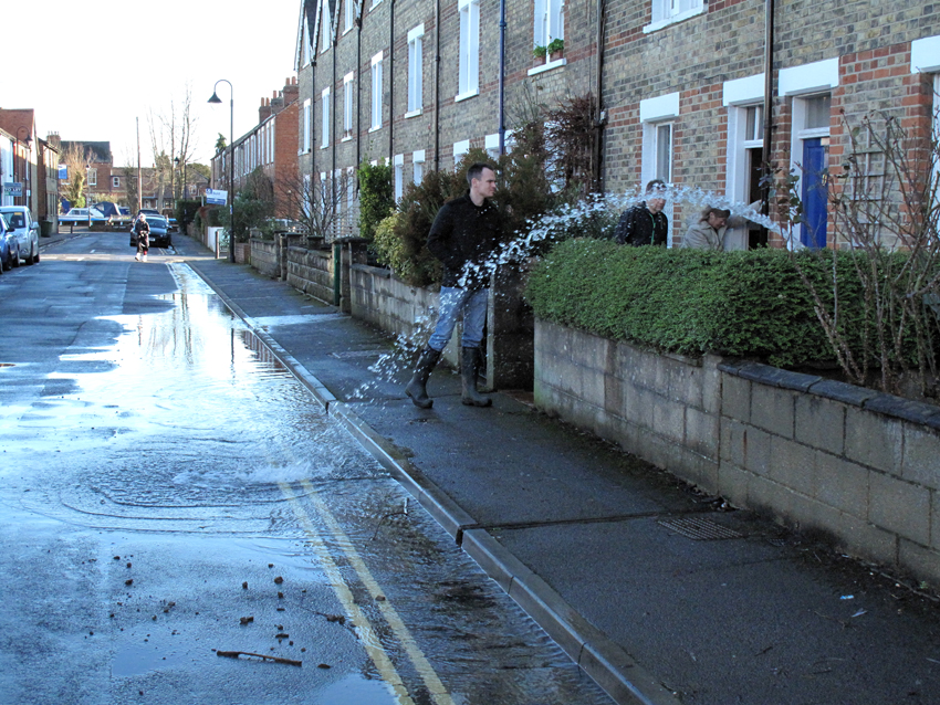
Simon spoke about being flooded in 2007, and the benefits which flood resilience measures brought during the 2014 floods when a submersible pump kept water out of the house (picture below). OFA has long been an advocate of property level resilience measures, and welcomes this new initiative from DEFRA.
Floodgates, air brick covers and pumps are, however, only effective up to a point. Household resilience measures have a contribution to make to flood risk management but they are not an alternative to the Oxford Flood Alleviation Scheme. We need both.
A number of West Oxford residents have recently been asking about how the existing right of way along Hinksey Causeway, also known as Monk’s Causeway, will be affected by the Oxford Flood Alleviation Scheme. This is the footpath which runs from The Fishes in North Hinksey to Osney Mead.
Information about footpath diversions is available here on the Oxford Flood Alleviation Scheme website. Scroll down to the relevant section. The impacts of the diverted public footpaths were assessed in the Environmental Statement Chapter 6 Recreation and Public Access, which forms part of the planning application for the scheme.
Two sections of Hinksey Causeway will be affected.
The first is the section which runs from Osney Mead past the electricity sub-station to where the ‘electric way’ starts (photo below). This path has to be moved 10m east to allow for the construction of a flood wall and flood gate, part of the flood defence which will run down the eastern side of Oatland’s Park and extends down to this area. This section of the path will be stone surfaced.
In the case of the other affected section, the issue is that the existing right of way doesn’t correspond to the path people actually use. OFAS will use the route people actually walk, so the legal right of way is being re-registered so the legal rights apply to the route people actually use. This section will have timber decking, a boardwalk. It will cross the two stage channel – an area which will be boggy at wet times of year.
Re-alignment of a public right of way is a legal process, hence the formal notices which have appeared recently in the press and along the path. The Environment Agency has to follow this process to establish the new legal rights of way. This path will remain a right of way and, apart from the initial section at Osney Mead, will follow the current route.
The footpath will be temporarily closed while it’s being constructed, this includes making a new footbridge, but people will have Willow Walk as an alternative.
This is a summary of information supplied to us by the Environment Agency under Open Public Licence.
Some critics of the Oxford Flood Alleviation Scheme have talked about the need for a ‘catchment-wide’ approach as an alternative. There are certainly benefits to thinking about the whole upper Thames catchment, but could such an approach deliver results within a meaningful timescale?
One issue OFA looked at early on, once the Flood Alleviation project was underway, was the potential for natural flood management techniques to contribute to reducing flood risk in Oxford. In August 2015 we organized a seminar and heard from a range of experts on this subject.
The overall conclusion was that natural flood-management techniques can bring benefits in smaller catchments, especially in lower-order flooding events. Isolated projects in the upper Thames would, however, have no measurable impact on Oxford with its large catchment (about 2,500 km2 upstream).
A complete re-landscaping of the Thames catchment might, if it could be achieved, reduce flood peaks by 10–15% – so helping with the flood risk but not solving it fully. Achieving the transformations in land-use necessary to deliver this benefit would require radical new legislation and/or a new culture of approaches to land management, taking ‘around 40 years’ to implement.
We found that storage could potentially play some role, but the volume of water involved in a major flood cannot be contained upstream of Oxford. The Environment Agency has always been clear about this. An effective upstream storage area would need to store approximately 50 million m3 of water. This is equivalent to an area the size of Oxford under 1 metre of water. There’s not enough capacity in the floodplain to store that amount of water.
The Environment Agency is exploring options for some future element of storage to mitigate against worsening climate change. Storage is not a viable alternative to the flood scheme but could be a useful backup in the future, as could major changes to land use upstream.
As well as these two options we also spent a lot of time looking at property-level resilience measures. Several steering group members made significant alterations to their homes to reduce the impact of floodwater in their property and speed up recovery after a flood. A number of us were allocated flood gates, air brick covers, and small submersible pumps by the City Council, funded by the EA. The pumps proved vital in Jan 2014 in keeping water out of vulnerable houses on Osney Island (see picture below).
There are things we can do at household level but these are only effective up to a certain scale of flooding. They are not a substitute for the flood scheme. Even with the scheme in place some properties still face risk and will need to deploy property-level defences.
We are expecting the County Council to decide on the planning application for the Oxford Flood Alleviation Scheme in the next few months. This is a major milestone for the project. Here’s a brief reminder of how we got here.
Back in the autumn of 2013 members of the OFA steering group met with the Environment Agency to discuss a list of ten ideas we had proposed for further reducing flood risk in the city. These ideas were additional to the ‘short-term measures’ already implemented following the 2007 floods.
The EA had analysed our suggestions. Some were discounted as the likely benefits were less than the cost, but some of the ideas they agreed would work. Their advice, however, was not to treat these as isolated projects, but to revisit the business case for a larger flood scheme capable of providing a much higher level of protection. The measures we had proposed would be more effective if they were part of such a scheme.
We agreed with this analysis and accepted that a further programme of short-term measures would bring limited benefit. The time had come to look to a more enduring solution.
The floods of January and February 2014 were a timely reminder of the risk the city faced and created the political momentum we needed to get the project moving, including strong support from national government. The plan which grew out of these discussions is the Oxford Flood Alleviation Scheme.
Large infrastructure projects start high level and become more and more detailed as they pass the hurdles set for each stage. OFAS has been developed in this way, with the output from each iteration subject to consultation, independent scrutiny, and approval by DEFRA and the Treasury. Over the past ten years the scheme has evolved, taking on board many suggestions from individuals and groups. This process has helped ensure the scheme is as good as it can be.
The project design for which the EA is seeking planning permission is the product of ten years of research, design, consultation, review and revision. We’re now at a point where we need a decision. The County Council planning officers have subjected the scheme to rigorous scrutiny. Elected councillors on the planning committee will make their decision, guided by the officers. This is the democratic process for agreeing how we go forward.
We very much hope the Council will decide for the project. Climate change is already increasing risk of flooding, and Oxford urgently needs a flood alleviation scheme.