
The floodplain west and south of Oxford has changed dramatically over the last 200 years. What we now think of as the main channel of the Thames, flowing past Osney Island, assumed its present form in 1790 when Osney Lock was built to improve navigation. Prior to that the Bulstake Stream, which flows through Tumbling Bay, round under Botley Rd to the west of the main Thames channel, and then turns east to run along the south of Osney Mead, was also a major channel.
The map below, from 1830, shows many recognisable features, and some notable absences. (North Hinksey was then in Berkshire and the county boundary is shown as a black dotted line.) The Seacourt, Hinksey and Bulstake Streams, and the River Thames, follow the courses we recognise now. But we also see streams and drainage ditches we don’t find today. On the other hand, Hogacre Ditch (see maps) which appears on later nineteenth-century maps does not yet exist, Willow Walk is yet to appear (built around 1880), there’s no railway (built in 1844) and the area which is now New Hinksey was fields all the way to the Thames.

Source: OS map 1830, detail, National Library of Scotland
In contrast, the map below, from the 1920s, shows a much less open landscape and a reduced floodplain with development along Abingdon and Botley Roads. The A34 has appeared to the west. Willow Walk, Monks’ Causeway and the Devil’s Backbone are there. So is Hogacre Ditch, showing as a continuous channel from North Hinksey across to the railway. This watercourse seems to have existed as a channel for only around 100 years. By 1961 the underground cables of the Electric Road had been laid, cutting Hogacre Ditch in half. The western section is now a dry ditch. The eastern portion is a backwater skirting the north of Hogacre Common and continuing on as Eastwyke Ditch down the eastern side of the Eco Park. Eastwyke Ditch runs under the railway, through New Hinksey, and eventually connects with the Thames.
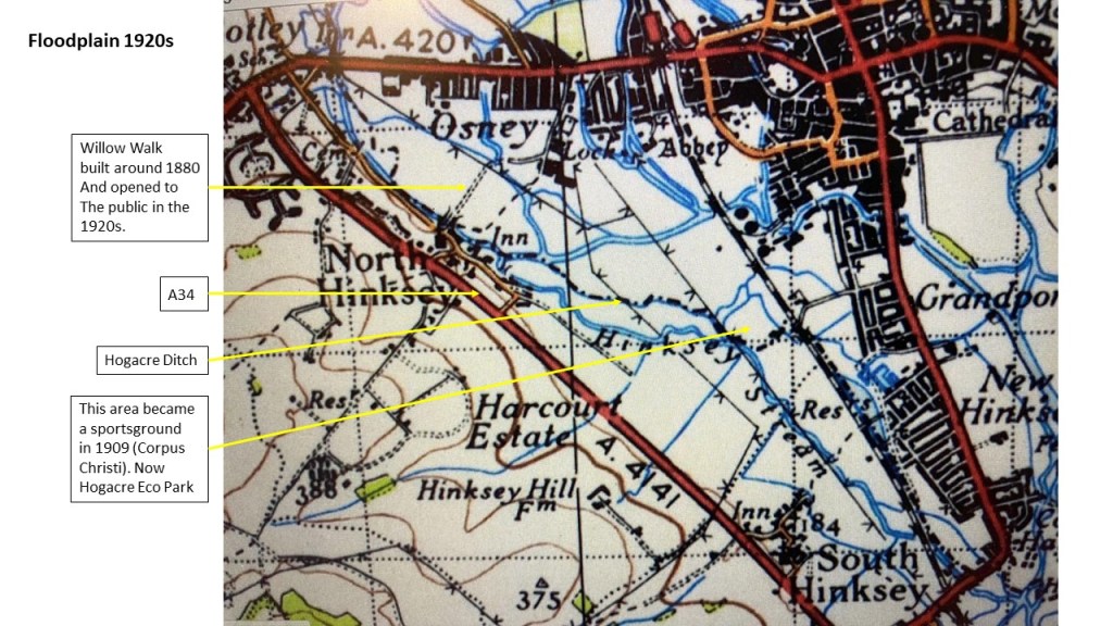
Source: OS map 1920s, detail, Vision of Britain
In their book Oxford and Its Countryside (1982) Ian Scargill and Alan Crosby, both from the Oxford University School of Geography, lament the impact of these many changes. They praise the unique character of Port Meadow, but go on to observe:
South of the Botley Road the Hinksey Meadows are another expanse of flat floodplain, but they were enclosed in the late eighteenth century and have a landscape quite different from Port Meadow. The area is low lying and to make it suitable for agriculture a network of ditches and watercourses was created, criss-crossing the flats and linking the two main branches of the Thames.
They mention the intrusion of electricity pylons, the railway and the A34 and comment:
Despite the obvious beauty of the streams that are bordered by willows and yellow flags, scattered with water lilies and scented with mint, the Hinksey Meadows have lost some of their overall charm and can no longer be regarded as one of the most attractive parts of the whole Oxford area.
Since Scargill and Crosby were writing, agricultural practices have changed. Today there is a range of environmental initiatives in this area that they would have applauded. Hinksey Meadow, owned and managed since 1997 by Oxford Preservation Trust, is a notable example. Public access to these meadows has increased greatly in recent years. The area today is a mosaic of habitats of varying character, quality, and ecological value, a legacy of human actions over many centuries.


(Left) Hinksey Meadow in all its glory, end June 2023. (Right) Abandoned field west of Osney Mead, July 2023
