Further update on flood alert

The Environment Agency updated it’s flood alert for the Thames and tributaries in the Oxford area this morning. The update reads as follows:

Property flooding is not currently expected.

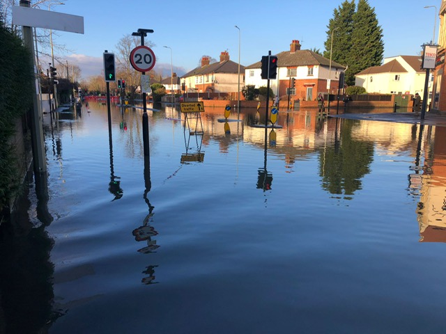
River levels are high on the River Thames as a result of heavy rainfall. Therefore, flooding of low lying land and roads is expected to continue today, Saturday. Today is expected to be dry. Sunday will start out dry followed by rain in the afternoon. We expect river levels to remain high over the next 24-48 hours as water moves downstream.

We are monitoring the situation. Our staff are managing weirs on the River Thames to reduce flood risk. Avoid using low lying footpaths near local watercourses. Go to the ‘River and Sea levels in England’ webpage for current river levels. This message will be updated tomorrow morning (29/09/2024), or as the situation changes.

Symposium delegates visit South Oxford

Around 30 delegates to a British Hydrological Society (BHS) symposium in Oxford took part in a field trip to South Oxford on 24 September. Oxford Flood Alliance member Simon Collings, Richard Harding of the Environment Agency and David Macdonald, hydrogeologist and South Oxford resident, co-hosted the visit, which they helped design.

The delegates had spent two days discussing developments in flood modelling and forecasting in the UK and internationally. Predicting the impacts of flood hazards is complex and takes into account many elements. These include the nature of the catchment, the ground conditions, groundwater levels, surface-water runoff, volume and intensity of rainfall, and sewer infrastructure.

Researchers are working to improve our understanding of each of these components and build integrated models to help better represent what happens during an event. The field visit provided an opportunity to learn about a specific flood-affected community, the measures being taken to reduce flood risk, and to think about the future application of some of the monitoring and forecasting tools presented at the symposium.

One topic of discussion was groundwater monitoring. In South Oxford this is currently very limited, with scope to improve data collection and potential benefits in using river data to indicate the likelihood of groundwater-related flooding. Some work is about to start on this with support from Project Groundwater, a government-funded initiative aiming to fill some of the gaps in our understanding of groundwater flooding. OFA is currently working with Project Groundwater to set up a flood group in the South Oxford area.

Abingdon Road 7 January 2024

Flood alert issued for Thames and tributaries

The Environment Agency has now issued a flood alert for the whole of the Thames from it’s source down to Twyford. The flood alert for Oxford, including areas between Wolvercote down to and including Radley and Jericho, reads:.

Property flooding is not currently expected. River levels are rising on the River Thames as a result of heavy rainfall over the weekend and earlier this week. Therefore, flooding of low lying land and roads is expected today, Wednesday 25/09/2024. Further rainfall is forecast over the next 24-48 hours. We expect river levels to continue rising slowly over the next few days. We are monitoring the situation. Our staff are managing weirs on the River Thames to reduce flood risk. Avoid using low lying footpaths near local watercourses. Go to the ‘River and Sea levels in England’ webpage for current river levels. This message will be updated this afternoon, 25/09/2024, or as the situation changes.

Rivers stabilising after record rainfall

The Thames and it’s tributaries upstream of Oxford have remained largely within their normal range and appear to be stabilising today, 25 September. Flow at Farmoor is just over 42 cumex, well below levels typically seen during flood events, and flow seems to be levelling off. The Environment Agency has said it expects rivers to stabilise during the day.

Various locations in Oxfordshire have experienced flooding, principally from surface water runoff, drainage systems being unable to cope with the sheer volume of water. The Cherwell, Ray and Thame rivers are also high and flood warnings are in place along stretches of these rivers, including near Banbury, Kidlington, and Abingdon. Flood alerts have been issued for some upstream sections of the Thames, but there are no alerts currently in Oxford city.

The Environment Agency is continuing to monitor the situation.

More than a month’s rain in one day

At 13.00 today, 23 September, the Osney rain gauge showed 67 mm of rainfall in the previous 24 hours, with heavy rain still falling. The average rainfall for September in Oxford is 54.38 mm.

Rainfall has been heavy across the catchment and clearly there will be a lot of water draining into the Thames over the coming days. Rivers are within their normal range currently, though rising in many places. Flood alerts have not yet been issued by the Environment Agency for Oxford but residents should monitor river levels and keep a watch on the situation.

Lots of reports of surface water flooding, school closures, traffic disruption appearing in the media.

We will post further information in due course.