OFA member Simon Collings was interviewed on BBC Radio Oxford this morning about the Oxford Flood Alleviation Scheme and the public inquiry into the Compulsory Purchase Order which starts today. Simon talked about the misery of being flooded and the need to be pressing on urgently with implementing the scheme. He rejected claims that there are better options than the one proposed by the Environment Agency, and he welcomed the inquiry as a fair method for resolving challenges from opponents of the scheme.
There wasn’t time during the interview to deal with a claim by the spokesperson for the opposition that the scheme will ‘destroy Hinksey Meadow’. This is not true. The Environment Agency has worked very hard to minimise the impact of the scheme on the meadow and has worked closely with the Floodplain Meadows Partnership, the UK experts, in designing the scheme.
Jon Mansbridge from the Environment Agency was also interviewed later in the morning. He explained what the flood alleviation scheme will deliver, both in reducing flood risk and environmental benefits. If the scheme gets approval it is hoped construction will begin in late 2024. It will take five years to complete the scheme but benefits will begin to accrue as elements of the project are put in place.
Fifty-one letters supporting the flood alleviation scheme have been sent to the CPO inquiry, most of them by people in areas of Oxford at risk of flooding. Oxford Flood Alliance contacted a number of long term residents with experience of flooding and asked them to write. Many of the letters recount residents personal, often harrowing, experiences of floods and make a powerful case for why we need the Oxford Flood Alleviation Scheme. These voices are representative of the community the Oxford Flood Alliance was set up to serve and on whose behalf we speak.
The public inquiry into objections to the compulsory purchase order, issued by the Environment Agency in connection with the flood alleviation scheme, will start on 14 November. Four members of the Oxford Flood Alliance Steering Group will be speaking at the inquiry in support of the scheme. We want the planning inspector who is hearing the objections to support the CPO.
The Environment Agency contacted around 400 landowners at the start of this year about more than 800 parcels of land which the agency needs to acquire to build the scheme. Some of these acquisitions will be temporary. There have been 27 objections from landowners, who are referred to as ‘statutory objectors’. The majority of these objections relate to specific land-related issues or to protection of infrastructure including railway assets and National Grid pylons. The Environment Agency expects to resolve many of these issues before the inquiry starts. Five of the statutory objectors oppose the flood scheme in principle or aspects of it.
There are also twenty-three ‘non-statutory objectors’, members of the public who do not own land subject to compulsory purchase. These objections range from concerns about future public access to the scheme area for recreation and dog walking through to environmental concerns about the scheme or aspects of the scheme.
OFA has been asking people in flood-affected communities in Oxford to write to the CPO inquiry in support of the flood scheme. It is important that the inspector hears the voices of people wanting the scheme to go ahead.
If you have not been approached by OFA but would like to write in support of the scheme you should send your comments in an email to the Programme Officer, Helen Wilson, who is supporting the Planning Inspector. Helen Wilson’s email is progofficer@aol.com. The deadline for letters is 5pm on 17 October.
The inquiry is being held at the King’s Centre, Osney Mead and is open to the public. Sessions run Tuesday-Thursday and in some weeks on a Friday. The hearings are scheduled to run for five weeks. OFA members expect to be speaking on the afternoon of 16 November. Information about the inquiry can be found here. All of the objections, with responses from the Environment Agency, are listed in Appendix 2 of the Statement of Case which is available from this link.
OFA has alerted the Environment Agency to potential maintenance work which may be required in two locations in the city. A member of the public contacted us recently about fallen trees and encroaching vegetation in the Weir’s Mill Stream near Donnington Bridge. We passed these comments, with photographs (see example below), to the Environment Agency who are arranging a site visit to assess the situation.
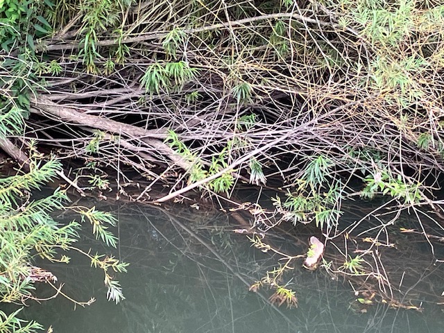
We also alerted the Environment Agency to a fallen Willow tree in the Bulstake Stream just north of Willow Walk (photo below). The branches are partially obstructing the channel. Maintenance work is scheduled on this stretch of river in September/October and the tree will be examined by the field team as part of their activity.
Maintenance of existing river channels is important for managing flood risk in the city. The Environment Agency carries out work on these streams annually. If you see fallen trees or other obstructions in the river which you think need attention please notify us.
The Secretary of State for the Environment, Food and Rural Affairs has confirmed that the public inquiry to consider the Compulsory Purchase Order (CPO) for the Oxford Flood Alleviation Scheme will begin on Tuesday 14 November 2023 and run for around 3 weeks. The inquiry will be held at The King’s Centre, Osney Mead, Oxford, OX2 0ES, and will be open to the public.
There will be a pre-inquiry meeting held on Thursday 21 September to consider how the inquiry will be run, to ensure it is conducted as efficiently as possible. Anyone who has objected to the CPO will be invited to attend.
In its latest newsletter, published today, the Environment Agency says:
‘A CPO public inquiry is standard procedure when objections are received. We welcome this opportunity for an independent inspector to hear the cases for and against the scheme. Following the public inquiry, the inspector will make a recommendation to the Secretary of State on whether or not the CPO should be confirmed. We expect it may take several months before the decision is known. We are confident the scheme as presented is the best option for reducing flood risk in Oxford. We are continuing our negotiations with landowners to attempt to resolve as many concerns as possible before the CPO public inquiry.’
The floodplain west and south of Oxford has changed dramatically over the last 200 years. What we now think of as the main channel of the Thames, flowing past Osney Island, assumed its present form in 1790 when Osney Lock was built to improve navigation. Prior to that the Bulstake Stream, which flows through Tumbling Bay, round under Botley Rd to the west of the main Thames channel, and then turns east to run along the south of Osney Mead, was also a major channel.
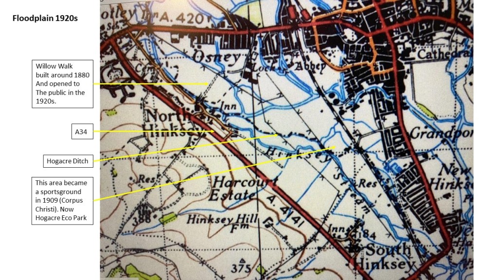
The map below, from 1830, shows many recognisable features, and some notable absences. (North Hinksey was then in Berkshire and the county boundary is shown as a black dotted line.) The Seacourt, Hinksey and Bulstake Streams, and the River Thames, follow the courses we recognise now. But we also see streams and drainage ditches we don’t find today. On the other hand, Hogacre Ditch (see maps) which appears on later nineteenth-century maps does not yet exist, Willow Walk is yet to appear (built around 1880), there’s no railway (built in 1844) and the area which is now New Hinksey was fields all the way to the Thames.
Source: OS map 1830, detail, National Library of Scotland
In contrast, the map below, from the 1920s, shows a much less open landscape and a reduced floodplain with development along Abingdon and Botley Roads. The A34 has appeared to the west. Willow Walk, Monks’ Causeway and the Devil’s Backbone are there. So is Hogacre Ditch, showing as a continuous channel from North Hinksey across to the railway. This watercourse seems to have existed as a channel for only around 100 years. By 1961 the underground cables of the Electric Road had been laid, cutting Hogacre Ditch in half. The western section is now a dry ditch. The eastern portion is a backwater skirting the north of Hogacre Common and continuing on as Eastwyke Ditch down the eastern side of the Eco Park. Eastwyke Ditch runs under the railway, through New Hinksey, and eventually connects with the Thames.
Source: OS map 1920s, detail, Vision of Britain
In their book Oxford and Its Countryside (1982) Ian Scargill and Alan Crosby, both from the Oxford University School of Geography, lament the impact of these many changes. They praise the unique character of Port Meadow, but go on to observe:
South of the Botley Road the Hinksey Meadows are another expanse of flat floodplain, but they were enclosed in the late eighteenth century and have a landscape quite different from Port Meadow. The area is low lying and to make it suitable for agriculture a network of ditches and watercourses was created, criss-crossing the flats and linking the two main branches of the Thames.
They mention the intrusion of electricity pylons, the railway and the A34 and comment:
Despite the obvious beauty of the streams that are bordered by willows and yellow flags, scattered with water lilies and scented with mint, the Hinksey Meadows have lost some of their overall charm and can no longer be regarded as one of the most attractive parts of the whole Oxford area.
Since Scargill and Crosby were writing, agricultural practices have changed. Today there is a range of environmental initiatives in this area that they would have applauded. Hinksey Meadow, owned and managed since 1997 by Oxford Preservation Trust, is a notable example. Public access to these meadows has increased greatly in recent years. The area today is a mosaic of habitats of varying character, quality, and ecological value, a legacy of human actions over many centuries.
(Left) Hinksey Meadow in all its glory, end June 2023. (Right) Abandoned field west of Osney Mead, July 2023
OFA Steering Group member Adrian Porter was on the BBC’s Morning Live on 19 July talking about the experience of being flooded. The interview with Adrian, who lives in South Hinksey, was part of a report on climate change and the growing risk of flooding in the UK. The item also featured a team of Oxfordshire Firefighters undergoing training in flood related rescue work. People trapped in vehicles in flood water, as shown on the programme, is typical of the kind of emergency the Fire Service has to respond to. But the service has also provided vital emergency support in Oxford in recent years by deploying pumps to keep roads and residential areas clear of flood water. This report was a powerful reminder that flooding has a serious impact on people’s lives and that the risk of it happening is increasing. The programme’s take away: home and business owners need to be prepared in the same way the Fire Service ensures its personnel are prepared.
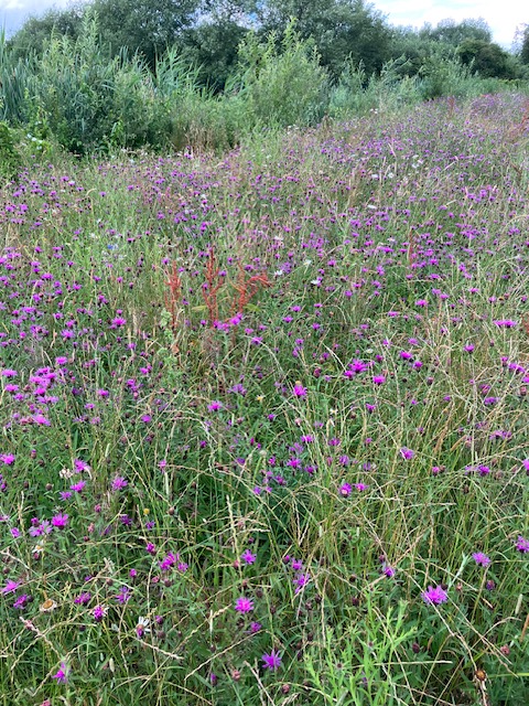
In 2019 the Environment Agency built a fish pass just to the north of Tumbling Bay in Botley Park. An area of scrub was cleared and a small channel excavated to allow fish to navigate around the weirs in the bathing area, and access the Thames.
The area between the fish pass and the bathing pool was seeded with a wild-flower mix, and in recent weeks the meadow has been a glorious sight. There is lots of knapweed, also ox-eye daisy and lady’s bedstraw, and plenty of butterflies including gatekeepers (photo below), small skippers, meadow browns, and green-veined whites. The stream itself is also rich in vegetation.
This illustrates how just three years on, an area which was cleared, excavated and re-profiled can already be looking attractive and providing habitat to wildlife. If the Oxford Flood Alleviation Scheme does get built we expect to see many areas recovering similarly quickly.
Protecting individual properties from flooding, and enabling those which do flood to recover quickly, is still in its infancy in the UK. Few companies make and sell flood-protection products, and few builders know how to make a house or business flood resilient. The new BeFloodReady centre at Wallingford, which launched in May, aims to change all this. Four members of the OFA Steering Group went to see what the centre might offer those of us at risk of flooding.
It’s an impressive set up, with a teaching room and a series of flood-resilient rooms which are used to provide accredited training to professionals. There are two reception rooms, a bathroom and a kitchen (pictured below), all of which can be filled with water. The rooms have a variety of floor coverings and types of wall construction to simulate different scenarios. They are used to demonstrate how a flooded property can be dried out and restored quickly, given the right equipment and processes.
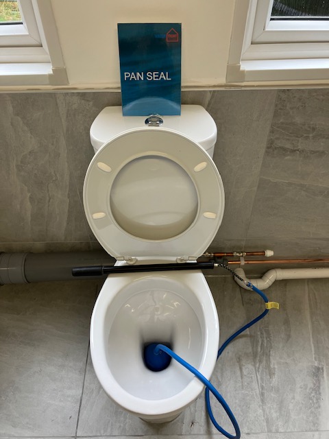
In the teaching area there is a display of different types of flood barriers, air bricks and air-brick covers, flood-resistant doors, and other products. Some items, such as doors, are expensive, but a simple device like a lavatory bung (pictured below), which can prevent sewage flooding your home, is easily affordable.
As well as providing practical training, the centre has developed a series of standards for the design, installation and maintenance of property-level resilience measures. This work is led by Graham Brogden MBE, who spoke at OFA’s tenth annual public meeting back in 2018. Graham was working for Aviva then and talked about how insurers were starting to pay much closer attention to property-level flood resilience.
During our visit Graham talked us through the code which has been created to standardise Property Flood Resilience (PFR) measures across the country. Over time this should help raise the quality of service property owners receive from professional providers of flood protection. The code provides property owners with a standard against which to evaluate anyone offering advice and services in this area. This short video explains the approach: https://www.youtube.com/watch?v=4sZv6Z3O8BA
Graham showed us an online platform, based on the code, which can be used by professionals to capture data on individual properties, inform the design of solutions, and enable monitoring of their effectiveness. The platform, developed by Resilico, also has a free app which householders can download to their phones. This provides flood alerts, including warnings of surface-water flooding, and includes a template for creating a bespoke flood-preparedness plan for your home or business. You can even set up reminders to periodically check that equipment like pumps and flood gates are in good working order. Search your app store for ResilicoConnect.
The insurance industry is increasingly focusing on the adoption of Property Flood Protection measures with Flood Re due to phase out in 2039. ‘Flood Re has already started its transition plan,’ Graham told us, ‘and this heavily relies on properties being made more resilient to flooding, using both resistant and recoverability measures, to help reduce the impact flooding can have on a property. They have also recently introduced the Build Back Better scheme, which a number of insurers have signed up to. This means that when a property floods Flood Re will provide an additional £10,000 on top of the repair costs to help make the property more resilient for the future.’
Even with the Oxford Flood Alleviation Scheme in place, there will be homes and businesses in Oxford that remain at some level of flood risk. For those properties, flood resilience will remain important and the Wallingford centre will be a useful resource. If the flood scheme is built the number of properties which remain at risk will be much reduced. This will mean that targeted interventions to improve property-level resilience for those communities still needing protection could be feasible.
The BeFloodReady centre is the UK’s first dedicated facility to deliver accredited training. It is funded by Defra as part of the government’s PFR Pathfinders programme which aims to increase knowledge and skills in the building and insurance industries around property flood resilience. OFA visited the centre on 5 July 2023. For more information visit: https://www.befloodready.uk/
Critics of the Oxford Flood Alleviation Scheme claim that the proposed new stream and secondary channel deliver little benefit. Oxford Flood Alliance disagrees. We were formed in 2007 by people from communities most vulnerable to flooding. We believe that the proposed two-stage channel is vital to protect those communities.
The planning application documents include an updated comparison between the scheme as designed and the scheme minus the two-stage channel (Appendix Q to the Environmental Statement). This document shows clearly that those communities OFA grew out of, especially those along the Botley Road, would flood more frequently and to a greater depth without the channel.
In an event with a 20% chance of happening in a given year, the kind of event we might expect to see every 5 years, Duke St starts to flood without the channel.
In a 5% chance event Duke and Earl St flood, so does Marlborough Court. With the channel, only Duke St is affected. Flooding on Osney Island is more extensive than with the channel, though some areas are affected even with the channel.
In a 2% chance event Bulstake Close would go under without the channel, sections of Botley Rd would flood, flooding on Osney would be more extensive than with the channel, and St Frideswide’s church and vicarage would flood. Earl and Duke St, and Marlborough Court flood at this level even with the channel. Flood depths will be greater without the channel.
In a 1% chance event Mill St and adjoining streets flood without a channel, as do Henry Rd, Helen Rd, Binsey Lane, and the whole of Old Botley. There is extensive flooding on Osney. Parts of Grandpont, Jericho, St Thomas and Hythe Bridge St also flood without a channel.
There is no perfect scheme and the most vulnerable communities are already having to accept that the project cannot protect them against a 1% chance event, or even in some cases a 5% chance event. Community and household-level flood defences will still be needed in these situations. The scheme with ‘no channel’ would be significantly less effective.
Overall, the flood alleviation scheme has to balance a range of competing interests. Protecting all homes and businesses at risk from a 1% chance event is not achievable. It would cost too much and have too great an impact on the local environment. OFA believes the proposed scheme is a reasonable compromise between improving flood protection for the city and meeting concerns about cost, disruption to people’s lives, biodiversity and recreation.
If you live or work in any of the flood-affected areas, or travel through these areas for work or school, you will be better off with the channel.