The Seacourt Park and Ride extension opened again yesterday after being closed for 19 days due to flooding. This is the second flood event at the facility this year, bring the total time the car park has been close due to flooding to 54 days.
Author Archives: Simon Collings
Seacourt P&R flooded in just 8 hours
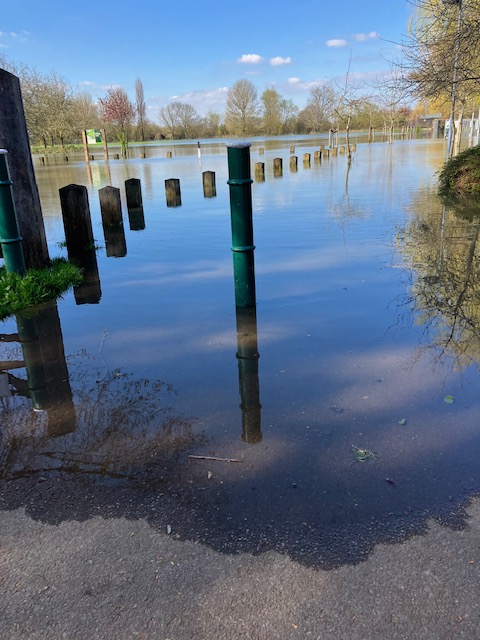
On Monday 3 April the Seacourt Park and Ride extension went from being largely dry in the morning to being underwater 8 hrs later. Here’s a picture of the car park taken by a local resident early on Monday morning:

This video clip, taken at around 10.30 the same morning, shows the rapidly rising water. You can see the water spreading across the car park in real time.
By 6.30 pm the car park looked like this:

And here’s a video clip which shows the flooded facility on Tuesday morning.
Oxford City Council shut the car park first thing on Monday morning, but the pedestrian and cycle pathway was not closed until 24 hours later, with many people trying to use it on the Monday. Some turned back on encountering the flooding but others took their chances, ploughing through the floodwater in an attempt to access the bus stop.
The flood happened on a weekday. Given the speed of the rising water levels, there remains a question as to how promptly action would be taken at weekends, overnight, and on bank holidays, particularly to ensure the safety of pedestrians and cyclists. Water started to appear in the car park on the Saturday morning (1 April), when several cars were still parked there.
OFA identified safety issues as an area of concern during the planning process for the car park extension. River levels have not been especially high in this event. The level of the Seacourt stream at Minns estate, across the road from the Park and Ride, was 0.3 m below its peak in January this year.
Speed of recent river level rises concerning
The striking thing about the flooding of the past few days is the speed at which river levels rose following several hours of torrential rain on the evening of Friday 31 March. This resulted in some flood events not previously seen in the county.
Tescos Extra in Abingdon was closed for two days due to a flooded car park, and Oxfordshire Wildlife Rescue suspend its operations after its centre near Didcot flooded on the Friday night. We have had reports of flooding at Sunningwell, north-west of Abingdon, and of flash flooding in Hurst Rise Rd and Hutchcombe Rd in west Oxford. The Eynsham Rd near the junction with the A420 was closed for a while due to flooding.
Botley Park. and the allotments to the east of the park, went from being completely dry on the Saturday afternoon to being flooded 24hrs later. Plot holders were taken by surprise at the speed at which their allotments flooded. At Seacourt P&R, the extension was fully flooded within 24 hrs.
Fortunately the amount of rainfall on Friday was not enough to cause more widespread disruption, but the speed at which rivers rose after just a few hours of heavy rain illustrate how vulnerable we would be in the event of a much bigger storm, and not just those areas known to be at risk from floods.
River levels have now stabilized in Oxford and Abingdon. Further up the Thames levels are either stable or falling.
River levels rising again
River levels in Oxford have been rising again over the last few days following the heavy rainfall on 31 March. The Environment Agency rain gauge at Osney recorded 25.1mm of rail that day, and 5.2mm the day before. The gauge at Eynsham clocked 32.5mm of rain on 31 March and 4.4mm the day before. At the top of the Thames catchment Shorncote measured 21.7mm of rain on 31 March. Here’s a video of the deluge shot in South Hinksey on 31 March.
The rate of flow at Farmoor was 69.900 m3/s at 15.45 today, higher than the peak flow rate in the January floods. The rate is still going up. Currently levels in the city are rising slowly but are still well below those reached on 18 January.
Seacourt P&R extension started to flood on 1 April, with several cars parked there at the time. These have since been moved. The car park is now closed.

What’s in the OFAS planning application additional information?
Navigating your way around the OFAS planning documents can seem daunting. This is a very large and complex project. You’ll find the documents at the County Planning Portal – https://myeplanning.oxfordshire.gov.uk/Disclaimer?returnUrl=%2F. You have to click ‘accept’ on this page before searching for the OFAS application. The application reference number is MW.0027/22. Click on the ‘documents’ tab for the application to view the planning documents.
If you toggle the ‘date’ filter you should get all of the most recently material appearing at the top. The document ‘Regulation 25 Further Information Request – schedule of changes’ details what has changed since the original application was submitted last year. There is also a summary of changes in the Addendum to the Planning Statement.
Most areas of the plan documents are unchanged, but there have been revisions to the way biodiversity loss/gain is calculated and how this is compensated for. The biodiversity analysis has been updated using the latest DEFRA methodology. Revised scorings based on this new methodology have led to some changes in scheme approach, including necessitating some off-site mitigation of specific types of habitat loss.
Overall the plan continues to demonstrate what will soon be the legally required level of biodiversity gain. The new Planning Statement Addendum says:
The calculation shows a net gain of 11.24% habitats, 11.66% hedgerows and 15.22% rivers with off-site mitigation. For some categories of habitats such as hedgerows and wet woodlands we are providing some replacement habitat on site but will also need to provide some offsite. We are replacing as much as possible on site but we cannot replace like for like habitat in the lowered area of the floodplain.
Other changes/additions to the planning documents are:
• An updated Agricultural Holdings impact assessment
• An updated Environmental Action Plan to address queries
• Updated information on Air Quality
• Updated landscape and planting plans
• A minor update to the No-channel Modelling Report
• Inclusion of the Carbon Calculator detailing the calculations used to estimate the carbon emissions figures quoted in the ES
• Additional Information on the options assessed for the proposed 2 stage channel route alignment
• An updated Landscape and Habitat Creation – Delivery and Management Plan.
You can search the planning site for documents relevant to topics you may be interested in. Oxford Flood Alliance supports the scheme as proposed by the Environment Agency. We are members of the Sponsoring Group for the scheme.
Additional OFAS planning documents
The additional information requested by Oxfordshire County Council planning officers in respect of the Oxford Flood Alleviation Scheme planning application is now published on the planning portal: https://myeplanning.oxfordshire.gov.uk/Planning/Display/MW.0027/22#undefined
Members of the public can submit comments on these additional documents. The deadline for comment is 17 April 2024.
Latest news on Oxford Flood Alleviation scheme
The Environment Agency recently submitted further information on its main planning application for the Oxford Flood Alleviation Scheme to Oxfordshire County Council. This was requested following a public consultation on the application last year. The council is expected to hold a consultation on the Environment Agency’s response shortly, after which it will determine the scheme application.
The Environment Agency will also be making a Compulsory Purchase Order (CPO) to acquire the land necessary to build and operate the scheme. We will share more information on the CPO process when it becomes available.
The scheme’s newsletter provides an update on these and other developments. You can read it below:
We are working with 9 partners on a major new flood scheme for Oxford, which will reduce flood risk to homes, businesses and vital transport routes into the city. The scheme will provide a long term solution to flooding in Oxford, helping protect the city in coming decades as flood risk increases with climate change.
The scheme will run through the existing floodplain west of Oxford. It will be formed of a new stream surrounded by a sloping floodplain of new wetland habitat and grazing meadow, to create more space for water away from built-up areas.
Scheme update
We submitted our planning application for the scheme to Oxfordshire County Council in 2022 and a consultation on our proposals was held. The council subsequently asked us to provide some further information, which is quite normal for a project of this size and complexity. We have now submitted our response to the request for further information and the council will organise a public consultation on our response. You will be able to find more details on the Oxfordshire County Council ePlanning system. The planning reference is MW.0027/22.
Our Compulsory Purchase Order (CPO) for the scheme has been finalised. We will issue notices to landowners shortly and the documents will then be submitted to the Secretary of State for Environment, Food and Rural Affairs. A CPO will ensure that all the land necessary to construct the scheme is available. The Secretary of State will determine the process for deciding the CPO and will set out the timetable for this in due course. We have engaged with landowners and will continue to do so throughout the planning and CPO process.
We will also be submitting a separate planning application to construct a temporary access track to the Hinksey Rail Sidings. We expect to submit this by May 2023. If this application is approved, the temporary access track will allow us to remove some of the material excavated during construction by rail. Use of the railway will depend on us gaining permission to access the sidings, their availability, and agreements with the operator of the sidings.
Protecting the City’s infrastructure
Significant floods in past decades have not only caused property damage to homes and businesses in Oxford, they have also closed the railway and major roads, bringing the city to a standstill. This level of disruption will be specifically memorable for people who experienced the floods of 2003, 2007 or 2013/2014. Floodwater cut off Botley and Abingdon Roads, closed the railway line and caused devastation to many homes and businesses.

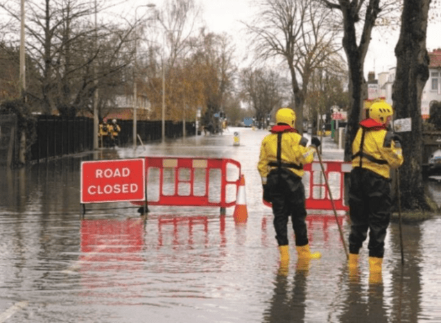
Flooding and road closure on Abingdon Road in November 2012
The Oxford Flood Alleviation Scheme will help keep the main railway line, Abingdon Road, Botley Road and local roads open in floods. There will also be fewer flood related interruptions to utility services, including water, electricity, phone and internet, and less likelihood of schools and essential community services needing to close.

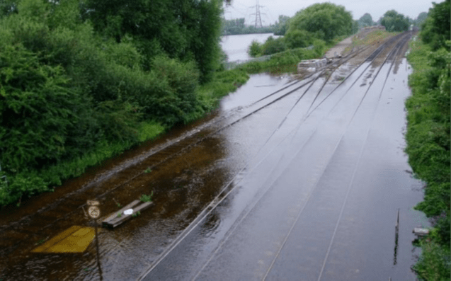
Flooded railway tracks in Oxford in 2007
Oxford relies on functioning and resilient infrastructure in order to stay open for business and to support its vibrant tourist economy. Oxford is known as a thriving centre of commerce. It is home to around 4,700 businesses and provides 135,000 jobs. Road closures, diversions and longer journey times due to flooding would impact the tens of thousands of people who commute into or travel through Oxford by bus or car every day. The scheme will significantly reduce the chance of this disruption due to flooding.
The scheme will also bring wellbeing benefits to communities in and around Oxford. Thousands of residents who are currently affected when the city floods will be able to enjoy improved peace of mind without the worry of flooding and the green spaces of the scheme will enhance the enjoyment of recreation in the local area for generations to come.
Keep safe from flooding
Polls as part of the Environment Agency Public Flood Survey in March 2021 suggest nearly 2 in 3 households at risk from flooding do not believe their homes could flood. But just because flooding hasn’t happened to you in the past, it doesn’t mean it won’t happen in the future.
In England there are over 5 million properties at risk of flooding. With climate change already causing more frequent, intense flooding and rising sea levels, we all need to know what to do should the worst happen.
Taking steps to prepare for flooding and knowing what to do in a flood can significantly reduce the risks to individuals and damages to homes and possessions.
Follow us to keep updated on the scheme – and please share this newsletter
oxfordscheme@environment-agency.gov.uk
www.gov.uk/government/publications/oxford-flood-scheme/oxford-flood-scheme
Oxpens redevelopment flood compensation
OFA is pleased to note the approach being taken in the Flood Risk Assessment which forms part of the OXWED planning application. At the insistence of the Environment Agency the developers have adopted a ‘level for level’ approach to flood compensation, meaning that any reduction in floodplain capacity at a given level has to be compensated for by an increase in capacity at that same level. This is the standard we would expect to see applied.
The development will also allow flood water to enter voids beneath some of the built structures.
Up to date flood modelling has been used in the assessment, and allowance has been included for the proposed new bridge over the Thames (which will be part of a separate planning application).
Calculations in the FRA show an overall net gain in flood plain capacity for all levels of flooding. This will help to reduce flood risk in the city. The EA is now reviewing these proposals and will provide its comments to the planning authority. OFA welcomes the robust approach being taken.
During 2021 OFA took part in several meetings between the OXWED developers and members of St Ebbe’s New Development Residents Association (SENDRA) where flood risk was being discussed. Community members highlighted concerns about continuing erosion of the riverbank at Oxpens Meadow. These concerns are acknowledged in the planning documents with provisions included to address them.
Some SENDRA members were also interested in the potential to improve the biodiversity of the meadow, an interest OFA shares. The planning application includes proposals for a net gain in biodiversity which is assessed to be in excess of 10%. This is achieved through additions to hedgerows, numbers of ecologically valuable trees, and sowing of the meadow with a richer mix of grasses.
Going forward we expect to see similarly robust approaches on flood risk being applied to other planned development in this area, especially Osney Mead. We also want to see areas set aside for biodiversity being linked so that green corridors continue to serve wildlife in the area. Protecting and enhancing the diverse habitat provided by the main river and its margins will be critical.
Seacourt Park & Ride extension open again
The extension to Seacourt Park & Ride reopened on Wednesday 8 February after being closed on 5 January due to flooding. The City Council acted promptly to prevent access to the extension once flooding became likely. The facility, which is designed to flood, was closed for a total of 35 days. In the planning application the City Council estimated that the car park would be out of use because of flooding for an average of 10 days a year. We argued at the time that this was an under-estimation. Construction of the facility, which OFA opposed, resulted in a net loss of floodplain capacity.

River levels falling
River levels are now falling in Oxford and we expect to see floodwater begin to drain away over the coming weeks. The flood peaked yesterday, 18 January, when the Thames south of Osney Lock reached 3.58m, the Bulstake at New Botley recorded 2.64m, and the Seacourt at Minns estate was at 2.68m.
These levels are below those recorded two years ago, on 3 February 2021, when the Thames at Osney reached 3.73m, the Bulstake 2.80m and the Seacourt 2.90m.
The 2021 event was the most serious flooding since the floods of January and February 2014. On 9 January that year the Thames downstream of Osney lock recorded 3.93m, the Bulstake 3.02m and the Seacourt 3.08m. Some properties were affected by the 2014 flooding. A second wave of flooding in February reached similar levels, though not quite as high.
We’ve been pleased with the level of preparedness and response from the various agencies involved this year. We have been sharing photographs of this year’s flooding with the Environment Agency to assist them in checking assumptions in the flood model used to manage response to high rainfall and river levels.

Fields near South Hinksey, 18 January