Application by Oxford City Council to extend Seacourt Park & Ride

Application by Oxford City Council to extend Seacourt Park & Ride  (Oxford City Planning application no. 16/02745/CT3).

We are strongly opposed to this application to build a car park extension right in the Oxford floodplain.

Our key points are:

Inappropriate development in the floodplain – contrary to Oxford City Council Core Strategy, CS2 – this is a greenfield site. It is also contrary to City Council Core Strategy 11 – it is neither ‘essential infrastructure’ nor ‘a water compatible structure’.

Not consistent with national planning policy framework (NPPF) guidelines.

Inappropriate development in the Green Belt.

A planning application for a similar scheme on the same site was rejected by the Secretary of State in 1999. Planning law has become tighter since.

County Transport Strategy envisages new P&R sites at Cumnor and Eynsham over the next few years; the present proposal is at variance with that. Traffic coming off the A34 and A420 may face increased delays in reaching the P&R.

Flood-risk assessment flawed:

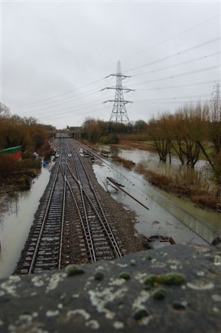
  • fails to note the serious floods since 2008
  • does not properly consider the frequency with which this low lying site actually floods, which is often (it’s functional floodplain)
  • permeable pavement recommended only slows run-off when flood event are so low risk it’s irrelevant. As soon as a significant flood event starts to develop the car park will be under water.

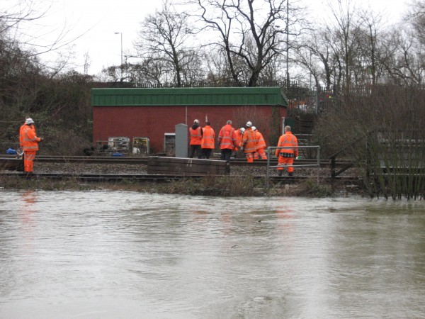
Emergency evacuation plan is inadequate and lacks detail. The site is at high risk of flooding, being 0.5-1 m lower than the existing car park. There is a significant risk to vehicles and people during a flood event: any emergency plan has to be very robust. Extra resources could be needed from already stretched emergency services. In a 1 in 100 flood the water would be 2m deep.

The ground is subject to movement and would require further investigation to see if remediable stabilisation would even work.

The site itself may be damaged by prolonged or severe flooding, even with surfaces broken and swept away. The fences proposed for the perimeter of the 2 ha site, and structures on the site, would be very vulnerable in a large scale flood.

The proposed permeable surface will be impaired by silt and other debris: it will require cleaning which may or may not restore its permeability. After prolonged flooding such paving may even have to be replaced (in early 2014 this site would have been under a significant depth of water for several months).

If fences, structures on the site, and cars were swept away they could end up blocking the nearby Seacourt which is a vital flood channel.

The proposal does not take proper account of the latest plans for the Oxford Flood Alleviation Scheme in this area.

The rationale for this extension being needed is that the present car park cannot be given a decking storey because of a covenant on the land. No such covenant has been produced by the applicant and we cannot find one. What there is is a lease agreement, with could potentially be varied by negotiation with the landlord, which could make this whole scheme unnecessary.

Oxford is at risk of flooding. The principle of not building on greenfield sites in the floodplain must be adhered to.

These reasons are set out in more detail in the following documents submitted to the planning authority, Oxford City Council (links download pdfs).

  1. Our initial objections (28 Nov 2016)
  2. Further points (5 Dec 2016)
  3. Address to Council (5 Dec 2016)

We are working hard to get our message across to the decision makers and to other people who may wish to comment. If you agree with us that this development should not be allowed to go ahead please do say so via the Oxford City planning website or speak to your local City Councillor.

Further comment on Network Rail’s planning application for track-raising

We submitted our comments on the latest revision (A02) of Network Rail’s flood risk assessment (FRA) for their planning application for track-raising yesterday.

The planning application is number 15/03703 and details can be found on Oxford City Council’s planning portal https://www.oxford.gov.uk/info/20066/planning_applications/328/view_and_comment_on_planning_applications

The application is going to West Area Planning Committee for determination on 3 May at 2 pm at the Town Hall.

See also our earlier post https://oxfordfloodalliance.org.uk/2016/03/28/network-rails-planning-application-for-track-raising/

Network Rail’s planning application for track-raising

Network Rail (NR) has applied for planning permission in relation to its plan to raise a particularly low area of the mainline track to London, beneath and either side of the old Abingdon Road bridge (Redbridge) near Kennington, to reduce the risk of the line flooding. Doing only this would increase the risk of flooding to the west of the line by raising the height of what is already a dam to the free flow of flood water. So NR propose a new culvert beneath the railway to compensate for this.

We have no objection to this plan in principle, but it must be done properly to ensure that the flood risk to properties and roads is not increased. If the mitigating culvert is too big areas to the east would be affected, too small and those to the west would suffer.

NR then need to convince the planning authority that their proposal gets the balance right and does not increase anyone’s flood risk. This is done mainly by modelling of flood flows and levels and reporting the results as part of a Flood Risk Assessment (FRA) which is at the heart of the planning application. This was first submitted in February. We went over this with a fine-tooth comb and found gaps and serious inconsistencies in the data presented. We did not believe that the document allowed the necessary judgement to be made, indeed it raised more questions than it answered. We made a submission to the planning authority, Oxford City Council, suggesting that, on the available evidence, it would be unwise to allow the application. The FRA, our comments, and many other documents can be seen on the council’s planning website – application number 15/03703/FUL. Our comments: OFA comments on 15/03703/FUL – Construction of a culvert.

A revised FRA (Revision AO1) was tabled by NR on 25 February in response to comments made by the Environment Agency to them. Because of the timing this revision  did not deal with our questions. We submitted further comments on AO1, reiterating and expanding on key points, on 9 March. We again gave our opinion that the evidence presented in the FRA was such that it could not allow a safe and proper decision to be made. This submission: 15:03703:FUL OFA Comments on the revised FRA (revision AO1, Feb 2016) F

After making our second submission to the planners we met with representatives of NR and their advisers. They confirmed that there were indeed the errors we had drawn attention to, in both the original and AO1 revision of the FRA. They said they had identified the reason for these errors and explained this. We understand that they will be filing a further revision, plus an amended version of an associated document, GRIP3, which is referred to in the FRA.

We have discussed our concerns with the planning officer at the Council who has been helpful and attentive to our arguments. A decision on the application has now been deferred to allow time for the revised documents from NR to be reviewed by the public and by Council planning staff.

Postscript: we were later asked to review the maps associated with the FRA, to compare what the model suggested with what we know ‘on the ground’. Our comments: 15:03703:FUL – OFA Review of flood model maps.

PPS25

The government wants to rewrite planning guidance – we’re concerned that the current guidance (PPS25) controlling building in floodplains may be weakened or lost – so we’ve contributed to the consultation and written letters to the Oxford Times http://www.oxfordtimes.co.uk/news/opinions/letters/9274193.Serious_future_risk/ and our two MPs.