Catchment saturated after record rain

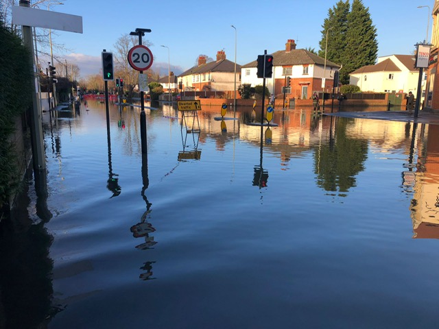
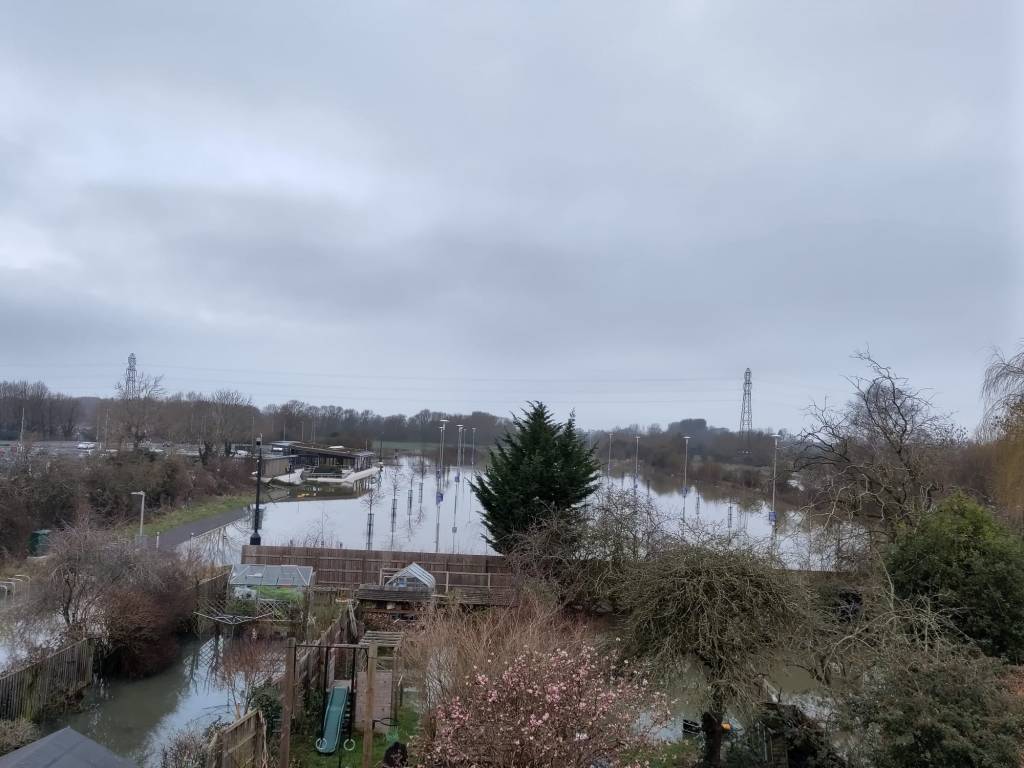
The Environment Agency has issued a report giving details of the exceptional rainfall in the Thames catchment in September and the consequences of this. It makes sobering reading. The capacity of soils to absorb more water has been reduced to virtually zero resulting in high river flows. The rising chalk groundwater aquifers are untypical for this time of year.

The report summary says:

Thames area received 193mm of rainfall in September, 317% of the long term average (LTA); making it the wettest month since records began in 1871. Following the high rainfall, soil moisture deficits (SMDs) were reduced to zero and this resulted in high effective rainfall of 50mm (LTA is 5mm). Monthly mean flows increased at all our sites and 4 measured their highest ever September flows since site records began. Due to the heavy rainfall, the seasonal declining trend of groundwater levels reversed at the majority of our indicator sites in September, which is earlier than normal.

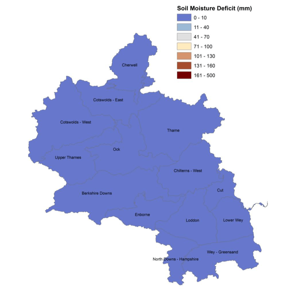
This map of soil water deficit (i.e. the available capacity in the soil to absorb more moisture) shows the situation graphically. The long term average is 88mm meaning we typically enter winter with some capacity in the system to absorb rainfall. Not this year,

This is Flood Awareness Week. If you’re concerned about potential flooding there is good advice on the government website about how to prepare for and protect against flooding. The EA report is the Monthly water situation report: Thames Area.

Flood Action Week 2024

Next week, 14-20 October, is Flood Action Week when the government will be raising awareness of flood risk and what we can do about it. Being prepared for flooding will reduce the impact, even if you only do a few basic things. Making your home flood resilient can, the government says, reduce the costs of repairs by up to 73%. Advice about what to do if you are at risk of flooding is available here.

Apart from protecting homes and businesses look out for flooding on roads and don’t drive through flood water. Most of those who die as a result of flooding in the UK do so because they tried to drive through a flood. Don’t chance it.

Take steps now to make sure you are as prepared and protected as possible.

Symposium delegates visit South Oxford

Around 30 delegates to a British Hydrological Society (BHS) symposium in Oxford took part in a field trip to South Oxford on 24 September. Oxford Flood Alliance member Simon Collings, Richard Harding of the Environment Agency and David Macdonald, hydrogeologist and South Oxford resident, co-hosted the visit, which they helped design.

The delegates had spent two days discussing developments in flood modelling and forecasting in the UK and internationally. Predicting the impacts of flood hazards is complex and takes into account many elements. These include the nature of the catchment, the ground conditions, groundwater levels, surface-water runoff, volume and intensity of rainfall, and sewer infrastructure.

Researchers are working to improve our understanding of each of these components and build integrated models to help better represent what happens during an event. The field visit provided an opportunity to learn about a specific flood-affected community, the measures being taken to reduce flood risk, and to think about the future application of some of the monitoring and forecasting tools presented at the symposium.

One topic of discussion was groundwater monitoring. In South Oxford this is currently very limited, with scope to improve data collection and potential benefits in using river data to indicate the likelihood of groundwater-related flooding. Some work is about to start on this with support from Project Groundwater, a government-funded initiative aiming to fill some of the gaps in our understanding of groundwater flooding. OFA is currently working with Project Groundwater to set up a flood group in the South Oxford area.

Abingdon Road 7 January 2024

Reducing flood risk by improving biodiversity

Can improving biodiversity in Oxfordshire contribute to reducing flood risk? We think it can and there are conversations taking place across the county which could move this forward.

Oxfordshire County Council is developing a Local Nature Recovery Strategy (LNRS) for the county. This flows from the 2021 Environment Act and government commitments to improve biodiversity across the UK. Oxford Flood Alliance has been participating in consultation meetings on the strategy. We’re interested in ways natural flood management in the catchment can help reduce flood risk.

The County is using expert advice alongside wide-ranging public consultation. Twelve workshops were held in March involving more than 300 participants, including conservationists, farmers and local government officers. A survey of local people received 650 responses. Results of these engagement activities were presented in an online meeting on 9 May attended by more than 100 people.

What matters most?

The two issues that gained the widest support from these consultations were improving the quality of our rivers and freshwater habitats and stopping river pollution from sewage and agricultural runoff. Benefits expected to come from this included reduced flooding (number 2 for the workshops and 3 in the survey result). There was also strong support for an end to building in the floodplain.  Thames Water cleaning up its act is critical to reducing pollution.

Simon Collings from OFA asked how reducing flood risk would be reflected in the priorities for  the strategy. Chloe Edwards, who leads on this work at the County Council, said this would be through identifying habitat improvements which included natural flood management to benefit properties and/or farmland. She said she expected this to be a significant component of the strategy.

How could this reduce flood risk?

LNRS is not the only county-wide strategy for dealing with flood risk, or even the main one, but slowing runoff and improving storage upstream across the Thames catchment could help. To see an example of this in action watch this video about the Evenlode Catchment Project. (The section of flood management starts around 9 mins in.)

Another example is outlined in the Bernwood, Otmoor, and Ray (BOR) strategy developed by BBOWT. The River Ray drains into the Cherwell, which joins the Thames in Oxford. The BBOWT plan is to create wetland areas which would slow the discharge of water from the Ray into the wider river system. Working with farmers will be critical in achieving this. The LNRS will incorporate existing initiatives like these as building blocks.

What does it mean for OFAS?

These strategies are not an alternative to the Oxford Flood Alleviation Scheme but they could help as climate change takes effect. They are also important for the survival of our wildlife. Connecting up areas of surviving biodiversity is seen as a key objective of the strategy. The OFAS scheme is designed to deliver biodiversity net gain as well as flood protection. The project could contribute to the creation of more joined-up habitat across the county.

The LNRS is intended to provide a focus for government funding decisions and a basis for various actors to collaborate. But it won’t be the only game in town. It is envisaged that there will still be a lot of other activity taking place over and above what’s included in the strategy.

OFA featured in podcast about flood resilience

Project Groundwater has just released the first of a new series of podcasts looking at different aspects of groundwater flooding. Episode 1 focuses on ‘resilience’ and features interviews with two academic experts on the topics, Dr Karen Potter and Dr Sarah Fitton, plus Simon Collings from Oxford Flood Alliance.

The term ‘resilience’ appears with increasing frequency in the literature about flooding, but what precisely is understood by this word is far from clear. It can mean a number of different things, and is often used to denote what is in fact a complex topic. Without being clear what we mean in any given context evaluating the success of actions to improve resilience could be difficult, and well-meaning interventions may in fact bring no benefit. There is also a risk that an emphasis on ‘community resilience’ in government policy could shift the burden of responding to floods onto communities, and away from the state. Getting he balance right will be critical.

There are things which those directly affected by flooding can do to protect their businesses and homes, and ensure they can recover quickly from a flood. But such measures need to be complemented by actions from the Environment Agency, local authorities and others, both at times of flooding and in modifying the built environment to reduce risk of property flooding.

The degree to which a group of residents has the ability, time and resources to improve their personal resilience as well as influence their wider environment, will vary from one location to another. There are risks of less well-off communities being left behind, and the degree to which ‘capacity’ can be built in vulnerable communities remains little understood.

The podcast, hosted by Katie Hargrave-Smith, lasts 40 mins and can be accessed here.

(OFA is working with Project Groundwater to try to establish a flood action group in South Oxford, an area of the city which has particular issues with groundwater.)

The ongoing saga of Seacourt P&R extension

Tuesday 9 April marks the 100th day of 2024 and Seacourt Park & Ride extension has not been open to the public for a single one of those days. Following flooding in January the council cleaned it on 2 February, presumably with an intention of opening it to the public. It had been free of all flooding and pooled water for about a week.  However, it had been raining in the preceding days, and the car park started to flood once more on 3 February, the very day after it had been cleaned. It has been underwater to a greater or lesser extent ever since.

Oxford Flood Alliance warned the council in 2016 that the proposed car park extension lay in Flood Zone 3b, the functional floodplain, and it was not suitable development for that location. National planning policy (the NPPF and its accompanying Technical Guidance) stipulates that a Flood Zone 3b location is only suitable for ‘water-compatible’ development and for ‘essential infrastructure… that would remain operational and safe for users in times of flood.’

We submitted at the time that the developer underestimated the extent to which the site flooded. Their consultants had projected that it would be shut on average for 10 days every year due to flooding, a conclusion they had reached by leaving the years of most extensive flooding out of their assessment. We argued at the time that this was an inaccurate representation of the true nature of the site, and did not account for climate change. So far this year alone, it has been shut for 10 times that anticipated duration.

By comparison, the Oxford Flood Alleviation Scheme is an example of the type of development in a Flood Zone 3b location that is compatible with the NPPF, since it remains operational in times of flood (to serve its very purpose) and also is ‘essential infrastructure’, helping to reduce the impact of flooding across Oxford. Oxford Flood Alliance supports this example of responsible development in the floodplain.

On this 100th day of 2024, the 100th day of the year on which the Seacourt Park & Ride extension remains closed to the public, we urge the council to give national and local planning policies the weight they deserve, in particular in relation to flooding. National planning policy exists for a good reason. It is a material consideration for planning committees, and they ignore it at their peril.

South Oxford flood meeting well attended

Last night’s meeting on flooding in South Oxford attracted around 70 local residents interested to learn more about what can be done to reduce flood risk. The meeting was hosted and introduced by Cllr Anna Railton, who set the scene by describing the floods of January and February this year and issues arising.

David Macdonald, a geo-hydrologist who lives locally, gave an overview of groundwater flooding which is a particular problem in South Oxford. Rising river levels push up groundwater, and one way to reduce risk, he said, is to lower river levels.

This is what the Oxford Flood Alleviation Scheme aims to achieve, and Richard Harding from the Environment Agency gave a quick overview of the project. Mat Lloyd, also from the EA, spoke briefly about community flood preparedness.

Karen Fisher and Jed Ramsay then talked about Project Groundwater, a Defra funded initiative which aims to build resilience in communities particularly affected by groundwater flooding. South Oxford is one of the areas they are specifically targeting with advice and support. One issue Jed talk about was early warning systems for groundwater using advanced technologies.

Simon Collings spoke finally about Oxford Flood Alliance and gave an example from January this year of the way community organisation prevented flooding.

At the end of the meeting a number of people expressed interest in learning more about becoming a flood warden and about developing a flood plan. OFA will working in partnership with Project Groundwater in helping to create enhanced community organisation around flooding in South Oxford. The resources which Project Groundwater bring to this venture provide a great opportunity for improving the community’s resilience.

Oxford Flood Alleviation Scheme, of course, remains critical to reducing flood risk in the city. Several people said they would be writing to the County Council urging them to give planning consent for the scheme.

Public meeting South Oxford 21 March 2024

Oxford Flood Alliance will be speaking at a public meeting on flooding in south Oxford and what can be done about it. This area of Oxford has particular issues with groundwater though the neighbourhood is also affected by river flooding.

David Macdonald, a hydrologist and local resident, will explain how groundwater flooding occurs, Jed Ramsay from Project Groundwater, a government funded initiative which is working with the community, will talk about local resilience and mitigation, Richard Harding from the Environment Agency will talk about the Oxford Flood Alleviation Scheme and how this will benefit local residents, and Simon Collings from OFA will talk about the work of the alliance.

The meeting has been organised by the local city councillors, Anna Railton and Naomi Waite, and will be chaired by Cllr Railton. Information about flood insurance, Project Groundwater and the Oxford Flood Alleviation Scheme will be available at the event.

The meeting will take place on 21 March, 7pm, at South Oxford Christian Centre, Wytham Street, OX1 4TW.

End to flooding in South Hinksey within reach

South Hinksey could have a permanent flood bund in place by the end of 2025 if the Oxford Flood Alleviation Scheme gets the go ahead in the coming months. The Environment Agency has said the permanent bund would be ‘upfront in the build programme’, so if spades went in the ground this year South Hinksey would start to benefit immediately.

Adrian Porter of OFA, who lives in the village, said. ‘By winter 2025 we’d likely be protected. With a bit of good luck later this year, this really could be our last flood.’

Demountable barriers are currently in place in South Hinksey because of the high floodwater levels. It is the second time this year the defences have been deployed. In January the barriers went up too late to stop some property flooding, so this time the EA have acted quickly to have equipment in place in case it’s needed.

The deployment of temporary defences, Adrian says, has become ‘depressingly normal’. There was a barrier deployment in 2021, a near deployment in 2022, and now two deployments in 2024.  

‘Each time the disruption for the community is significant,’ Adrian explains, ‘with the farm yard and car-park occupied, horses displaced, gardens churned up and rotas of people to keep an eye on things overnight as the EA don’t have the staff to do it themselves.’

The decision to deploy is made by an over-stretched agency with input from advisors, flood modelling data, on-the-ground photographs and other ground-truthing evidence. It is inevitably a balance of strategy, finance, operations and infrastructure. In January the EA got the timing wrong, an awful 48 hours ensued and several properties flooded as a result.

This is totally avoidable. OFAS, which is awaiting planning consent, would mean the village wouldn’t need to rely on the vagaries of human decision-making and temporary barriers. Protection would be there every day of every year.  

‘We are a beautifully diverse community of young and old,’ Adrian says, ‘who thrive despite the lack of pub and shop. We work so hard to make this the perfect place for children to grow up and for everyone to enjoy, but with flooding an ever-present threat it is hard to feel completely safe. There is a solution. Let’s get on and deliver the Oxford Flood Alleviation Scheme.’

The Oxford Mail picked up on this story. You can read their version online here.

Government failing on flood resilience

The Government does not know if it is making the UK more resilient to flooding. In a report published on 17 January 2024, the Public Accounts Committee (PAC) warns that the Department for Environment, Food and Rural Affairs (Defra) has no overall numerical target for the UK’s level of long-term flood resilience, and so cannot know if it is progressing in its 2020 ambition to create “a nation more resilient to future flood and coastal erosion risk”.

Flood protection will be provided for at least 40% fewer properties than planned, according to Environment Agency (EA) forecasts. This is due to factors including inflation and the bureaucracy associated with approving projects. With the programme’s success relying on the completion of many large projects where the EA has only medium or low confidence of delivering by 2027, the Committee is concerned that the number of properties better protected could turn out to be even fewer than the current revised-down forecast of 200,000.

In 2022-23, there were 5.7 million properties in England at risk of flooding. The Committee’s report highlights a range of concerns in Government’s support and approach to flood resilience, including:

  • smaller and rural communities losing out due to a lack of flood protection provision for communities of fewer than 100 houses that can nevertheless be devastated by the impact of flooding;
  • new housing continuing to be built in high flood risk areas without adequate mitigations, as over half of Local Planning Authorities said they rarely or never inspect a new development to check compliance with flood risk planning conditions;
  • a lack of necessary leadership and support from Government for local authorities on how to address the increasing risks of surface water flooding.

Due to a lack of funding, the Environment Agency (EA) has not been able to meet its target of maintaining 98% of its high consequence flood defences (which protect the most properties) at their required condition. The report highlights that 203,000 properties are at increased risk due to deteriorating flood defences, more than the 200,000 separate properties the Government expects to better protect through its ongoing capital programme by 2027. These figures illustrate that poor maintenance is undermining progress from new capital expenditure and Defra’s failure to establish what the appropriate balance is between building new defences and maintaining existing ones.

The National Flood Forum, an umbrella organisation representing local flood groups like OFA, has welcomed the report. The NFF believes that the government’s current approach is too focused on personal resilience. While this undoubtedly has a place, it should only be one part of a bigger bolder Government vision for flood mitigation. The NFF is calling on Government to adopt a strategy that embraces a truly multifaceted integrated approach to flood defence and that adequately tackles the impacts of future flood risk.

Read the Full Report (HTML)
Read the report summary