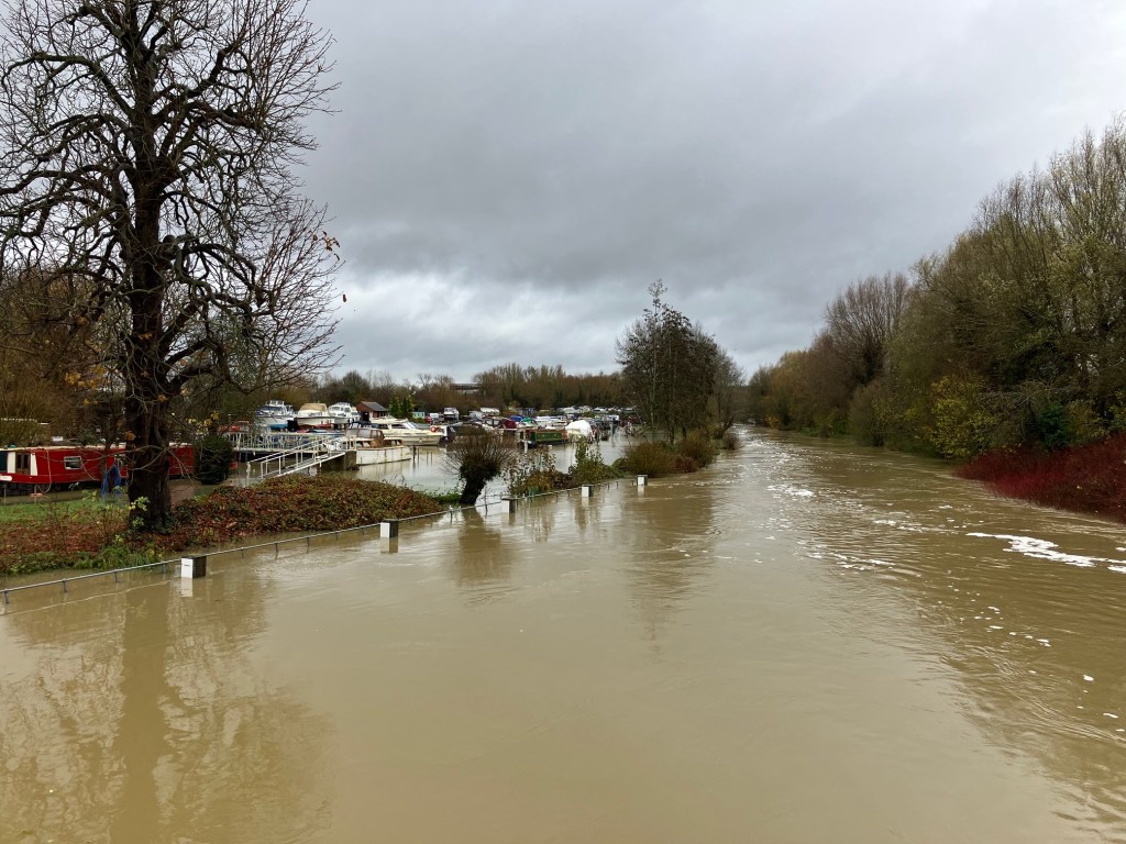
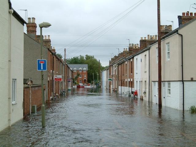
River levels in Oxford have peaked and are starting to fall after a week of disruption, with flood defences deployed in several parts of the city. Members of Oxford Flood Alliance have been busy working with residents and the authorities to make sure homes and businesses stay dry. Overall the emergency response has been well managed.
Intense rainfall was experienced across the catchment on Sunday 24 November. Minster Lovell rain gauge recorded 53.2 mm, almost a month’s worth of rain, in just 24 hours. St John’s Lechlade recorded 46.9 mm in the same period. Soils were already sodden after the record-breaking deluge at the end of September and predicting what might happen was challenging. The Environment Agency thought initially that we might see river levels similar to those in January this year.
In the event the floods were not as bad as feared, with the highest levels 150 mm lower than in January. There were two flood peaks in Oxford. The first came on 26 November, driven by the Evenlode and local surface water, the second on 29 November as water made its way down from the headwaters of the Thames. Levels are expected to remain high into early December with a lot of water still flowing through the city.
OFA is deeply frustrated that we have been waiting since the beginning of the year (albeit with a change of government during that period) for the Secretary of State at DEFRA to sign off on the compulsory purchase order for the Oxford Flood Alleviation Scheme. If the scheme were in place we would not have to experience the stress, disruption to daily life and costly emergency response seen over the last week.
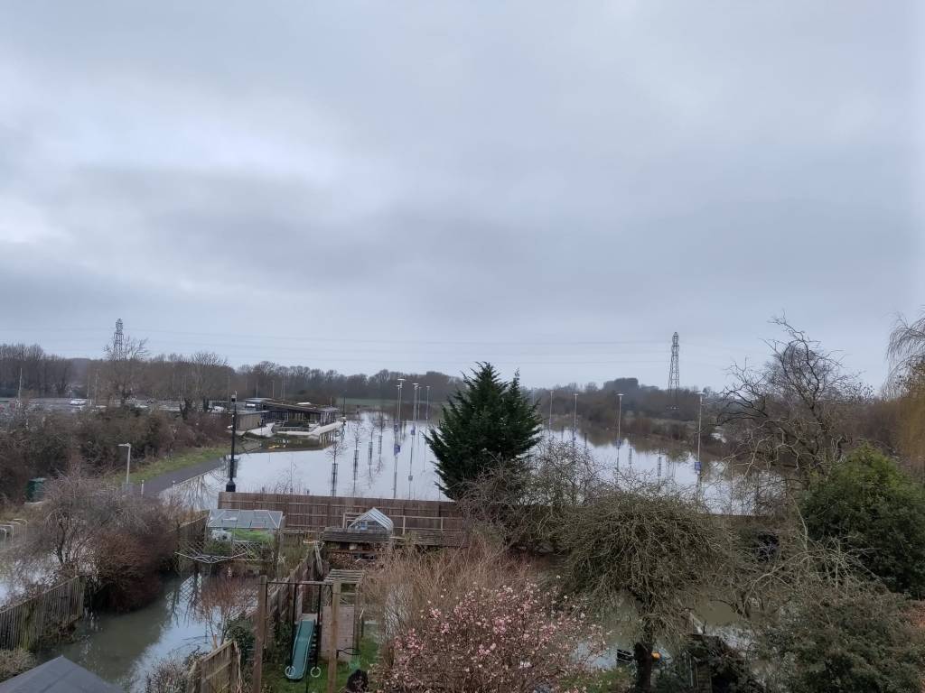
Tuesday 9 April marks the 100th day of 2024 and Seacourt Park & Ride extension has not been open to the public for a single one of those days. Following flooding in January the council cleaned it on 2 February, presumably with an intention of opening it to the public. It had been free of all flooding and pooled water for about a week. However, it had been raining in the preceding days, and the car park started to flood once more on 3 February, the very day after it had been cleaned. It has been underwater to a greater or lesser extent ever since.
Clean up 2 February11 February – back to this3 April – flooding still visible in the P&R extension
Oxford Flood Alliance warned the council in 2016 that the proposed car park extension lay in Flood Zone 3b, the functional floodplain, and it was not suitable development for that location. National planning policy (the NPPF and its accompanying Technical Guidance) stipulates that a Flood Zone 3b location is only suitable for ‘water-compatible’ development and for ‘essential infrastructure… that would remain operational and safe for users in times of flood.’
We submitted at the time that the developer underestimated the extent to which the site flooded. Their consultants had projected that it would be shut on average for 10 days every year due to flooding, a conclusion they had reached by leaving the years of most extensive flooding out of their assessment. We argued at the time that this was an inaccurate representation of the true nature of the site, and did not account for climate change. So far this year alone, it has been shut for 10 times that anticipated duration.
By comparison, the Oxford Flood Alleviation Scheme is an example of the type of development in a Flood Zone 3b location that is compatible with the NPPF, since it remains operational in times of flood (to serve its very purpose) and also is ‘essential infrastructure’, helping to reduce the impact of flooding across Oxford. Oxford Flood Alliance supports this example of responsible development in the floodplain.
On this 100th day of 2024, the 100th day of the year on which the Seacourt Park & Ride extension remains closed to the public, we urge the council to give national and local planning policies the weight they deserve, in particular in relation to flooding. National planning policy exists for a good reason. It is a material consideration for planning committees, and they ignore it at their peril.
The Government does not know if it is making the UK more resilient to flooding. In a report published on 17 January 2024, the Public Accounts Committee (PAC) warns that the Department for Environment, Food and Rural Affairs (Defra) has no overall numerical target for the UK’s level of long-term flood resilience, and so cannot know if it is progressing in its 2020 ambition to create “a nation more resilient to future flood and coastal erosion risk”.
Flood protection will be provided for at least 40% fewer properties than planned, according to Environment Agency (EA) forecasts. This is due to factors including inflation and the bureaucracy associated with approving projects. With the programme’s success relying on the completion of many large projects where the EA has only medium or low confidence of delivering by 2027, the Committee is concerned that the number of properties better protected could turn out to be even fewer than the current revised-down forecast of 200,000.
In 2022-23, there were 5.7 million properties in England at risk of flooding. The Committee’s report highlights a range of concerns in Government’s support and approach to flood resilience, including:
smaller and rural communities losing out due to a lack of flood protection provision for communities of fewer than 100 houses that can nevertheless be devastated by the impact of flooding;
new housing continuing to be built in high flood risk areas without adequate mitigations, as over half of Local Planning Authorities said they rarely or never inspect a new development to check compliance with flood risk planning conditions;
a lack of necessary leadership and support from Government for local authorities on how to address the increasing risks of surface water flooding.
Due to a lack of funding, the Environment Agency (EA) has not been able to meet its target of maintaining 98% of its high consequence flood defences (which protect the most properties) at their required condition. The report highlights that 203,000 properties are at increased risk due to deteriorating flood defences, more than the 200,000 separate properties the Government expects to better protect through its ongoing capital programme by 2027. These figures illustrate that poor maintenance is undermining progress from new capital expenditure and Defra’s failure to establish what the appropriate balance is between building new defences and maintaining existing ones.
The National Flood Forum, an umbrella organisation representing local flood groups like OFA, has welcomed the report. The NFF believes that the government’s current approach is too focused on personal resilience. While this undoubtedly has a place, it should only be one part of a bigger bolder Government vision for flood mitigation. The NFF is calling on Government to adopt a strategy that embraces a truly multifaceted integrated approach to flood defence and that adequately tackles the impacts of future flood risk.
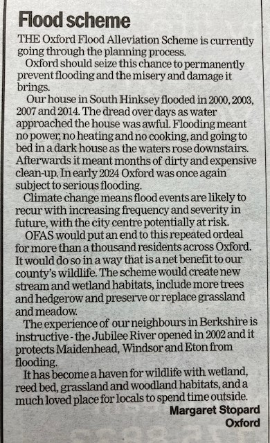
Today’s Oxford Times (8 February 2024) carries a letter supporting the flood alleviation scheme from Maggie Stoppard, the widow of Dr Peter Rawcliffe. Peter was one of the founders of the Oxford Flood Alliance. The letter describes Maggie’s personal experience of floods in South Hinksey, where she and Peter lived, and goes on to say:
‘In early 2024 Oxford was once again subject to serious flooding. Climate change means flood events are likely to recur with increasing frequency and severity in future, with the city centre potentially at risk.
OFAS would put an end to this repeated ordeal for more than a thousand residents across Oxford. It would do so in a way that is a net benefit to our county’s wildlife. The scheme would create new stream and wetland habitats, include more trees and hedgerow and preserve or replace grassland and meadow.’
Maggie’s letter appears alongside an Oxford Times editorial about the flooding in January of a number of sites across the county which are earmarked for housing development. Planning professionals are now calling for a rethink of housing plans, and their comments have attracted support from across the political spectrum. ‘Flood risk needs to be taken seriously by the planning authorities,’ says the editorial.
OFA fully endorses this view. One of the reasons we have problems with flooding in areas like Earl St and Duke St is because of bad planning decisions in prior decades. Building on the floodplain has to stop.
Fifty-seven residents from Earl St, Duke, St and Marlborough Court have written to the Leader of Oxfordshire County Council calling for construction work on the Oxford Flood Alleviation Scheme to begin urgently. They are frustrated that the scheme has been 10 years in design but there is still no firm date for when construction will start. These streets are some of the most vulnerable in Oxford and this January many residents relived the nightmare of past floods.
The letter, organsied by Earl St resident Dr Sebastiaan van Schaik, says:
Re: floods in West Oxford and the urgency of the Oxford Flood Alleviation Scheme
Dear Cllr Leffman,
I’m writing to you on behalf of 57 residents of Earl Street, Duke Street, and Marlborough Court in West Oxford. As I’m sure you are aware, West Oxford and the Abingdon Road areas were severely affected by the floods in early January. We’re grateful to the people from the EA and ODS who worked 24/7 to redirect water and reduce damage to the best of their abilities. Most floors have now dried, pumps are gone, and the electricity is back on, but the streets are still littered with sewage and road surfaces remain in urgent need of repair.
Needless to say, these floods come at a huge emotional and financial cost. For some of us, these were the first or most serious floods we’ve experienced; others still remember the trail of destruction left by the water back in 2000, 2003, 2007 and 2014. On top of that, the impact on local businesses is substantial, at a time many are already struggling. And all of us know: these floods could have been prevented.
In 2015, the Environment Agency first consulted with local residents and organisations on draft designs of Oxford’s Flood Alleviation Scheme (OFAS). Of all the different options to reduce flood risks, the proposed natural channel has been shown by detailed modelling to be the most effective, and residents cannot wait for the work to commence. With this channel, our streets and homes wouldn’t have flooded. But instead, 10 years on from the 2014 floods, not a single spade has touched soil. And we all know that climate change will only result in more frequent and more severe floods. We need action now.
It is profoundly disappointing that we are still waiting for work to start. And to West Oxford residents, there is a deep added irony: badly planned railway works have cut us off from the city we live in. Meanwhile, the Botley Interchange can apparently be closed at the drop of a hat, effectively cutting us off from both sides. Private companies like Thames Water are allowed to flood our streets with sewage, and are permitted to maintain a semi-permanent bike lane closure on Osney Bridge. And big, tall biotech labs can be designed, approved, and built in the area within only a few years.
Yet our local and central governments and agencies are somehow unable to commence work on a carefully-designed natural flood channel through empty grassland, in order to provide West Oxford residents with the most basic of comforts: a safe and dry home. We all understand the need for due diligence, careful planning application processes, and procedures around compulsory purchase orders, but at the current rate it is likely that some of us will not live to see the completion of this scheme. We feel deeply let down.
Therefore, on behalf of 57 residents of our streets, I urge you and the County Council you lead to please collaborate closely with central government and the Environment Agency in order to cut red tape and expedite the building of the Oxford Flood Alleviation Scheme.
At the same time, I urge our local City Councillors Pressel and Muddiman (both CC) to work with the County Council and EA to have the new flood channel completed as soon as possible. There are local elections coming up in 2024 (City) and 2025 (County), and it should not come as a surprise to anyone that this topic is high on the list of concerns of local residents.
Earl St in July 2007
Dr van Schaik was interviewed on BBC Radio Oxford on Monday 5 Feb, and the story was also picked up by the Oxford Mail, and the Oxford Clarion.
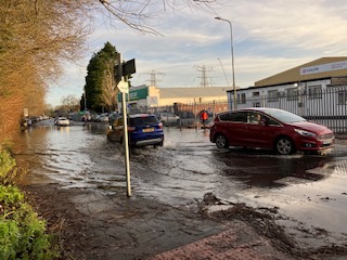
The Environment Agency issued a flood warning at 9.32am today for the River Thames and tributaries at New Botley, New Hinksey, North Hinksey, South Hinksey and Grandpont. The EA advise property flooding is expected. Their statement says: ‘River levels are rising on the River Thames and the watercourses around Oxford, including the Bulstake Stream as a result of heavy rainfall. Therefore, flooding of low lying land, roads and property is expected later this afternoon 04/01/2024, especially in the areas closest to the river in New Botley. Areas most at risk are properties on Botley Road, and the roads off Botley Road in New Botley.’
This is likely to be the most serious flooding we have seen since January 2014, the last big event. On 9 January 2014 the Thames south of Osney Lock peaked at 3.93m, the Bulstake Stream at 3.02m, and the Seacourt at 3.08. Current levels are around 30cms below those 2014 levels, but the river is sill rising with more heavy rain forecast. Current levels are higher than the Dec 2020 floods, and approaching the levels reached in February 2021, the previous worst flooding since 2014.
We understand that temporary defences will be erected at South Hinksey today and that the City Council is deploying defences behind Bulstake Close. The EA and local authorities are keeping the situation under close review and have teams ready to respond as need arises.
Everyone living in the affected areas should take the warnings seriously, monitor the evolving situation, and consider whether they need to take action to protect themselves and their property.
Bottom of Ferry Hinksey Rd this morning. End of Willow Walk also flooded.