Further comment on Osney Mead plans

In our previous post we highlighted a concern about the Supplementary Planning Documents for Osney Mead, which envisages ‘activating’ the riverbank south of Osney Lock and down to Grandpont nature reserve. The illustrations of what this might look like show a heavily urbanised and landscaped river frontage with paths and building all at the same level. We don’t believe this is consistent with the Thames towpath clearly being in flood zone 3b – functional floodplain.

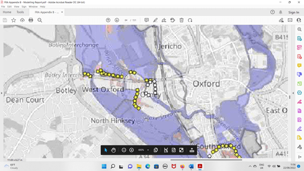
The image below is taken from the Flood Risk Assessment: Appendix B Modelling Report which forms part of the 2022 planning application for the Oxford Flood Alleviation Scheme. This figure shows flood risk for a 1 in 5 year scale event. Areas which flood when the scheme is in place are shown in blue. Areas protected from flooding by the scheme are shaded pink. The Osney Mead area is just south of the word ‘Osney’ (partly obscured by white squares) on the map. Note the wide blue area east of Osney Mead. This is the Thames south of Osney Lock, The river corridor floods even in these frequent, low-level events.

Flood risk for a 1 in 5 year event – OFAS planning documents

Any development proposal for Osney Mead will need to allow for a 1 in 100 year event, i.e. for much more severe flooding than shown above. The image below shows the extent of flooding expected in such an event. Significant areas of Osney Mead will be flooded. One of the challenges developers will have to overcome is ensuring safe exit routes for residents and people working in a redeveloped Osney Mead. Exit via the proposed new cycle bridge just south of the railway on the Thames will not be accessible as the towpath under the railway will be flooded. The streets at the southern end of Osney Island are likely to flood in such an event so will not provide a safe escape route either. The only way out by road, along Ferry Hinksey Rd, will also flood, as it does currently. The need to erect temporary flood barriers – the white squares on the map – also presents a challenge for any proposal to create new pedestrian and cycle routes through Osney Island. These issues have not been addressed in the Supplementary Planning Document.

Flood risk for a 1 in 100 event – OFAS planning documents

Our comments on Oxford Local Plan 2036

Oxford Local Plan 2036
“Oxford City Council is producing a new Local Plan for Oxford. The Local Plan is important because it will shape how Oxford develops.” (from the ‘Preferred Options’ document for the Plan, Oxford City Council). The Council called for comments and we wrote recently as follows:

We wish to submit the following comments in relation to the proposed Oxford Local Plan 2036. Our comments all relate to flood risk.

Overall we are satisfied that the City Council has adopted an appropriate strategic approach to development and flood risk in the city, with new development targeted towards areas least at risk from flooding. We welcome the recognition in the document that flooding is a significant risk for the city and that this needs to be managed.
 
On the specific sections relating to flooding in the Preferred Option, we would like to see reference to the need to actively maintain watercourses in the city so that they function freely during times of flooding. We’re surprised that the SFRA Decembrer 2016 makes no mention of the need for clearing of trash gates, and the removal of vegetation and fallen trees from streams and ditches. Riparian owners in the city need to be encouraged to maintain water courses.
 
On Option 38A we would prefer to see adoption of a policy which states that there will be no development of previously undeveloped land in flood zone 3b. As the SFRA notes, this is the position in the current Core Strategy and we see no argument for weakening this.The new plan does not designate greenfield sites in zone 3b for development.
We recognise that water compatible structures and essential infrastructure may, in exceptional circumstance, be permitted in zone 3b under the NPPF. But the Council’s recent attempts to argue that an extension to the Seacourt Park & Ride constituted ‘essential infrastructure’ caused the Oxford Flood Alliance considerable concern. While references to NPPF in the Council’s proposed Local Plan may appear to provide safeguards to the public, these are significantly weakened if the Council intends to ‘interpret’ NPPF along the lines argued for the P&R extension or similar. We believe the plan document needs to provide clarity on this.

 If Preferred Option 38A is adopted as proposed we wish to state for the record that we interpret this to mean that NPPF will be strictly applied. It is clear in Table 2 and 3 in this Guidance Note what ‘Water Compatible’ and ‘Essential Infrastructure’ mean. We are therefore interpreting the Council’s policy to mean what the NPPF guidance says it means. This does not include car parks.

In Option 56A we would like to see a reference to riparian owners responsibility to maintain water courses. Simply treating them as a design feature isn’t sufficient.


OFA Steering Group

OFAS – Public Consultation about to begin

Public consultation on the Oxford Flood Alleviation Scheme, OFAS, begins tomorrow.

See https://www.gov.uk/government/consultations/oxford-flood-alleviation-scheme-design-consultation for more about this, and tomorrow the dedicated consultation website should be available from the link there.


Visit by EA Chair

We joined Emma Howard Boyd, Chair of the Environment Agency, the OFAS Project Team and other partners when Emma visited Oxford today. The Public Consultation for the Oxford Flood Alleviation Scheme is due to be launched in two days time, on Friday 23 June.