
26 December 2012
Water levels in the area have crept up slowly today and are on the verge of flooding the lowest-lying houses in South Hinksey. The main-line rail track at Kennington is flooded.
26 December 2012
Water levels in the area have crept up slowly today and are on the verge of flooding the lowest-lying houses in South Hinksey. The main-line rail track at Kennington is flooded.
22 September 2012
Thames Water is about to begin work to sort out the area of Munday’s bridge under the railway in Kennington. As well as dealing with local flooding in Kennington, the work will allow the whole western floodplain to drain better, to the benefit of all in our area upstream. All credit, and thanks, to Thames Water for doing this substantial and important work. See http://www.oxfordtimes.co.uk/news/yourtown/oxford/9883845.Flood_prevention_scheme_goes_on_show/
We have been concerned about this area since we formed in 2007. That concern arose from the special local knowledge of John Mastroddi, a founder member of OFA’s Steering Group, who had been concerned for many years before that. His garden backs onto the site, although his house has never flooded. The local flooded community owes a debt to John and his wife, and their neighbours, for the sacrifices they are making so this work can be done: see our recent letter to the Oxford Times:
http://www.oxfordtimes.co.uk/forum/letters/9928463.Sacrifices_to_save_flood_misery/


22 March 2012
Work is well advanced in rehabilitating a ditch on the west edge of the Ferry Hinksey trading estate, at the east end of Willow Walk. We pointed out some time ago that this ditch had deteriorated to the extent of disappearing in places, and being completely cut off in others. Oxford City Council, led by engineer Steve Smith, designed and obtained government funding for the work. About 90% is now complete, but finishing is delayed by finding two high voltage cables that are not shown on any utility company records. Once this is sorted out the work will be completed. Well done to all concerned.
15 December 2011
Progress after years of trying! Thames Water have a project to improve flood water drainage off the Kennington Road and this will include extensive work at Munday’s to ensure that water can then get away from the area. This is extremely good news, as Munday’s is a severe pinchpoint holding water back in the floodplain west of the railway. Thames Water hope to start work in the spring.
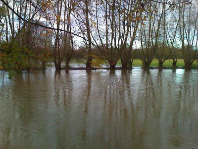
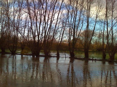
The photographs show the west bank of the Thames, just north of the Botley Road, above Tumbling Bay, on 12 November 2008. Water is breaching the bank in several places. The banks are eroded further with each successive flood.
We have suggested for the last three years (now December 2011) that this bank should be repaired; however there have been difficulties in achieving this, including much debate about how much it all matters. It would seem best that the area is looked at as dispassionately as possible, and computer modelling seems a good place to start. We would like the Environment Agency to assess what impact water, escaping from the river here early on, well before flooding of properties occurs, has on levels and flow in the Bulstake Stream, and on groundwater levels in the Botley Road area.


8 October 2011
This summer, Network Rail have carried out work to improve flow on Hinksey Drain as it passes under the railway access road north of the red brick road bridge near Kennington. Some of us have campaigned for this since 2004, before OFA was formed. It is excellent to see such a good job done – worth the wait! A big thank you to Network Rail.
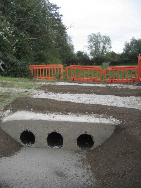
September 2011
The Vale of White Horse District Council has installed new culverts under a causeway across a field next to the village. This will keep flood water moving rather than pooling in this field. Thank you to District Engineer Peter Dela.
Edit: here in action in 2012, draining the field at the top:

17 June 2011


The City Council has obtained demountable barriers to go on top of the Earl Street road hump to keep flood water out of the street; and to keep water out of Bullstake Close.
20 January 2011
This is an exciting time!
Things in the Botley Road area which we have promoted and campaigned for for a long time are coming to fruition. The works will reduce flooding of properties by surface water. They result from cooperation between various bodies, including OFA.
At the end of 2008 we suggested setting up an inter-agency working party to concentrate on the Botley Road area. This was immediately taken up by the EA and agreed by the Oxford Area Flood Partnership in January 2009. Things began to move. Oxford City came up with the suggestion of a road hump at the top of Earl Street to redirect flood water; which fitted well with our suggestion that flood water be directed down Lamarsh Road instead of Earl Street, by lowering part of Lamarsh Road. The Earl Street hump is now going in – the result of work by County, City, EA and ourselves.
Very soon we expect work to start in Lamarsh Road, to lower the far end of the road. Here, as well as those already mentioned, developer Kingerlee has played a key role. A new flood route will in due course take floodwater away through the Kingerlee site to the flood meadows beyond.
Not far away, work is starting on another OFA-initiated project: the installation of flood culverts under Willow Walk. Much of the assessment and planning has been done by Oxford City in conjunction with the EA.


20 January 2011
Work is under way to put a raised road hump across the north end of Earl Street. It can be supplemented with sandbags when necessary. This will prevent flood water running down Earl Street as it has in the past. The County is carrying out the work, but the City, the EA and OFA have been involved throughout.
