
9 August 2009
Several Oxford Mail articles on a new flood map for Oxford published 14 July, 15 July, 15 July, 16 July, 2009 (sorry we’re a bit late). [Edit: 14 July link removed as no longer works.]
Tag Archives: Environment Agency
Communications
28 July 2009
Adrian Long, Director of Communications for the EA visited Oxford with Geoff Bell (EA) and met with Nick Hills of OFA. Talk was of the benefits to all concerned of collaborative working, good communications (of course!) and getting the various agencies to work together.
Future short-term measures
16 July 2009
Andy Webber made a presentation on behalf of OFA to the Oxford Area Flood Partnership (OAFP).
OFA’s principal message was to stress the importance of capitalising on the work already done in clearing the Seacourt/Hinksey Stream from the Botley Road to The Fishes in North Hinksey – and the work which has been or is about to be done to remove serious pinchpoints at Redbridge. The Hinksey Stream between these two areas must now be cleared of obstructions, so allowing the good work already done to have maximum benefit.
Our message was well received. The EA is a principal player in this – the local EA team agree how important this work is and are keen to see it done. Let us hope funding is made available.
OFRMS
3 June 2009
Following the public consultation the National Review Group (NRG) of the Environment Agency, an internal EA group, is considering the major long-term flood scheme for Oxford, the Oxford Flood Risk Management Strategy (OFRMS). A presentation, which we contributed to by helping with video clips, was made today. As soon as we hear the outcome we will let you know. Even if they give the ok, the scheme will still be a long way from being confirmed. There will be further detailed design work, more public consultation and then the biggest hurdle, submission to the government of the day for funding.
Munday’s bridge, April 2009

Before – note the concrete wall across the channel!

After – the concrete wall removed

Hinksey Drain. Culvert under the railway now cleared and channel on towards Hinksey Stream opened up.
Munday’s underbridge in north Kennington, where the Hinksey Drain passes under the mainline railway. Work to improve things has been carried out by the EA this month. The area is greatly improved, thank you EA.
But more needs to be done.
Railway access road – new culverts
6 March 2009

A tree cut hard back and shrubs cleared preparatory to work beginning at the railway access road at Redbridge.
Edit: As at early June we still await a firm start date; work was originally hoped to start last December. We are assured by the EA that the money remains available and that the work will go ahead.
Well done to the Environment Agency
3 March 2009
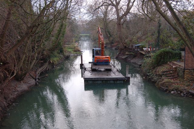
Clearing the Bullstake Stream looking from Botley Rd bridge
For their clearance of the Bulstake Stream and Osney Ditch and parts of the Hinksey/Seacourt Stream from Botley Road bridge as far as The Fishes pub, North Hinksey. This was completed in the winter of 2008. It will help water get away from the Botley Road area. To get the full benefit of this work the streams between here and Redbridge need to be cleared in similar fashion: we understand this is probably to be included in Short-Term Measures for the 2009/10 financial year. We very much hope that this will be confirmed.
100-year flood protection scheme for Oxford
12 February 2009
The Environment Agency’s Oxford Flood Risk Management Strategy is a plan for making Oxford “flood-proof”, to a 1 in 100 year level. It has been worked on for several years and the proposals are due to go public on February 18th 2009. There will then be a 12 week period for public consultation.
Botley Road area – action
Earl Street, Duke Street and Bulstake Close were badly affected by flooding in 2000, 2003 and 2007. In the past year four things have been done (or are about to be done) to help:
1. Oxfordshire County Council has installed a culvert from the south end of Duke Street onto King George’s Meadow beyond.
2 . The footpath at the bottom of Earl Street has been recontoured to improve the flow of water into the alleyway leading to Duke Street.
3 . Clearance of Osney Ditch and the Bulstake and Seacourt Streams south of the Botley Road in Autumn / Winter 2008 by the EA.
4 . Improvements at Redbridge are due to be carried out in March 2009. This should benefit everyone upstream.
As discussed on the Background page the flooding in these streets is a tricky and complicated problem; there is no quick fix. OFA has put forward a number of suggestions over the past year; getting progress has been slow because of the complexity and interdependence of many factors, the need to deal with several agencies and the scale and cost of some potential remedies.
Setting up a dedicated group would, we hope, help achieve results and so we proposed to the EA and to the Oxford Area Flood Partnership (OAFP) that an Inter-Agency Working Party be set up to consider this area, produce solutions and implement them. This was formally agreed to at an OAFP meeting in January 2009. The first meeting should be held in February or early March 2009. Members of this group will come from the EA, Thames Water, Oxford City Council, Oxfordshire County Council and OFA. Edit: held March 19th 2009.
OFA intends that this should be a main focus for action during 2009. We have a number of ideas which we believe merit consideration:
1. Installation of a culvert from Earl Street to King George’s meadow.
2. Alteration of the drains so that water entering the drains north of the Botley Road does not end up in Duke and Earl Streets as it does at present. Thames Water and Oxford City have already begun to examine this.
3. Reprofiling the Botley Road so that floodwater which at present flows across it into Earl and Duke Streets no longer does so. Instead it could be routed down Lamarsh Road and on via a (new) culvert through the site owned by Kingerlee and earmarked for development at the southern end. It would have to be certain that the commercial premises in Lamarsh Road would not be put at risk. And the agreement of Kingerlee would be essential.
4 The west bank of the Thames just north of the Botley Road is low so that water flows out of the river onto the fields in large amounts whenever the river is full. This in turn erodes the banks further. It is not clear where this water then goes but it must be a possibility that it contributes to flooding in Earl and Duke Streets and Bullstake Close. More information is needed.
5 Willow Walk may act as a barrier to the movement of flood water downstream. This needs to be verified and the EA has agreed to see whether it already has relevant floodwater level data. Closely related is the poor state of the ditch along the eastern edge of Oatlands Park, with partial or total obstruction in several places. Alternative routes are already under active consideration by OFA and the City Council. The overall solution may be to reroute the ditch, to provide culverts under Willow Walk, or to do both.
Oxford City proposes to build a wall to protect Bullstake Close. The effect of this on Earl and Duke Streets is not fully clear and we have asked the EA to evaluate this, to ensure no worsening of flooding will result for those streets.
