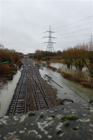
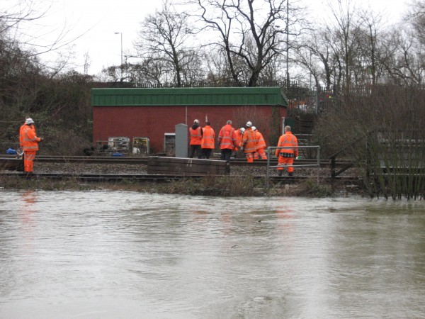
Seacourt P&R in the Oxford Mail; smart signs, plus risk to life

This article in the Oxford Mail talks about the possibility of  ‘smart signs’ – electronic boards – on the ring road, to alert drivers to where there are empty park and ride spaces around Oxford. This could obviate the (claimed) need to increase the number of spaces at Seacourt, instead pointing drivers to (say) nearby Redbridge. According to an earlier report in the Oxford Mail there is apparently so much spare capacity at Redbridge that the City Council proposes to remove 270 parking spaces, and is quoted in the newspaper as saying that the loss of these spaces would be ‘marginal’.

It seems to us to be inconsistent for the City Council to argue that removing 270 spaces at Redbridge is perfectly ok, while at the same time arguing a burning need to build new spaces at Seacourt – in the floodplain, on Green Belt land, contrary to local and national planning guidance and, as far as the present application goes, creating a potential risk to life (see towards the end of the first newspaper article and our previous post). Never mind the cost, which has already risen from about £2million to over £4 million.


Seacourt P&R extension proposal: potential risk to life

Liz Sawyer, who recently joined the OFA Steering Group, addressed Oxford City’s Full Council on 6 February 2017, about the potential risk to life posed by the proposed extension to Seacourt P&R.

There is also, as the photograph above shows so vividly, the potential for damage to the car park itself – and of course to vehicles. The Automobile Association’s ‘Flood Facts’ quoted in Liz’s address set out the risks of floodwaters very clearly.

Liz’s address can be downloaded here (pdf).

South Hinksey ‘barrier-ready’ works all but complete

In South Hinksey, the works designed to make deploying temporary defences, should flooding threaten, quicker and easier, are almost complete.

Three flap valves have just been installed on pipes which connect into field ditches. These non-return valves will allow water out from within any temporary barrier but not allow it back in from the flooded area outside.

Elsewhere wide garden gates have been installed, reinforced fences built, and removable fence panels fitted.

A very few minor snagging items remain, but the scheme is otherwise complete and fully ready for temporary barriers. Many thanks to the Vale of White Horse District Council for funding and to the Environment Agency for organising the work – not least to engineer Magnus Williams who has managed the scheme from its inception to its completion. Thanks too to farmer Nick Frearson, and to the horse owners for their cooperation during the works.

Dedicated pump for Earl Street

http://www.itv.com/news/meridian/2017-01-13/oxford-street-gets-dedicated-flood-pump-after-securing-grant/

The link provides an excellent report, including a video, about the arrival of a new pump, dedicated to flood protection for Earl Street.  In case that stops being available online here is an extract from the report, with acknowledgement and thanks to ITV:

“Today residents in Earl Street were shown a new, dedicated, mobile pump that will be available to them in the event of future floods.

Nick Hills, an Earl Street resident and member of the Oxford Flood Alliance Steering Group, applied for a grant to pay for the pump after becoming aware of Scottish and Southern Energy Network’s Community Resilience Fund. The energy company awards grants of up to £20,000 to community projects. His bid was successful and SSE awarded the full cost of the pump, which had been reduced to £19,830 by Stuart Pumps Ltd, which provides the City Council with its pumps.

Whilst we in Earl Street have been extremely well served by the local authorities in terms of flood avoidance, protection and resilience, there have been occasions in the early stages of a flood when we were desperately waiting for a decision to be made by both the Environment Agency and the City Council as to where they should deploy their limited number of mobile auxiliary pumps.
Understandably, it was impossible for either of these agencies to guarantee that we would have a pump deployed here in Earl Street while the situation was still evolving.
Now we have our own pump, as soon as the water starts to rise, we can say ‘can we have our pump?’ and it guarantees that it will be here when we need it.  – Nick Hills

 
Local MP, Nicola Blackwood, attended the pump’s unveiling today. She said while shorter-term flood projects like this are crucial, a planned flood relief channel will be a ‘game-changer’ when it comes to reducing flooding risk in the long-term.The £120m project would work by diverting flood water across the open flood plain and away from properties which currently flood.”

Finally, a big thanks from all concerned to Scottish & Southern Electricity Networks, who very generously funded the pump from their Community Resilience Fund.
 

Another letter about Seacourt P&R

Our letter published in the Oxford Times, 29 December 2016

We wrote recently about Oxford City Council’s proposal to extend the Seacourt Park & Ride into the flood plain, providing 658 extra parking spaces.

Now we read that the very same council wishes to abolish 270 parking spaces at Redbridge in order to develop a recycling facility. The core argument put forward by the City Council to justify their proposal at Seacourt is that extra car parking is so badly needed that it should be allowed even though the expansion site is in Green Belt and functional floodplain, and despite the fact that it is clearly contrary to national planning guidance and could put vehicles and people at risk during a flood. The Redbridge plans now make nonsense of the special case being advanced for Seacourt.

If that is not enough, the budget for construction of an extension at Seacourt has recently doubled from about £2 million to £4.1 million. The City Council Executive Board papers for 15 December 2016 show projected net revenue from the Seacourt Park & Ride extension of £160,000 a year, and this relies on an increase in parking charges from £2 to £3 possibly starting in autumn 2017.

At this rate the investment would take more than 25 years to pay back. If this figure assumes that the car park remains fully operational and doesn’t ever flood, when in reality it will do so virtually every year causing closure and expensive maintenance, the payback time will be even longer than 25 years.

We are discussing our concerns with the City Council as we believe that their proposal is ill-conceived and unjustifiable and that it should be abandoned before any more money is spent.

Further comment on Network Rail’s planning application for track-raising

We submitted our comments on the latest revision (A02) of Network Rail’s flood risk assessment (FRA) for their planning application for track-raising yesterday.

The planning application is number 15/03703 and details can be found on Oxford City Council’s planning portal https://www.oxford.gov.uk/info/20066/planning_applications/328/view_and_comment_on_planning_applications

The application is going to West Area Planning Committee for determination on 3 May at 2 pm at the Town Hall.

See also our earlier post https://oxfordfloodalliance.org.uk/2016/03/28/network-rails-planning-application-for-track-raising/

Network Rail’s planning application for track-raising

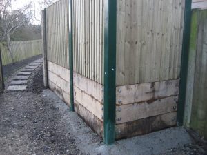
Network Rail (NR) has applied for planning permission in relation to its plan to raise a particularly low area of the mainline track to London, beneath and either side of the old Abingdon Road bridge (Redbridge) near Kennington, to reduce the risk of the line flooding. Doing only this would increase the risk of flooding to the west of the line by raising the height of what is already a dam to the free flow of flood water. So NR propose a new culvert beneath the railway to compensate for this.

We have no objection to this plan in principle, but it must be done properly to ensure that the flood risk to properties and roads is not increased. If the mitigating culvert is too big areas to the east would be affected, too small and those to the west would suffer.

NR then need to convince the planning authority that their proposal gets the balance right and does not increase anyone’s flood risk. This is done mainly by modelling of flood flows and levels and reporting the results as part of a Flood Risk Assessment (FRA) which is at the heart of the planning application. This was first submitted in February. We went over this with a fine-tooth comb and found gaps and serious inconsistencies in the data presented. We did not believe that the document allowed the necessary judgement to be made, indeed it raised more questions than it answered. We made a submission to the planning authority, Oxford City Council, suggesting that, on the available evidence, it would be unwise to allow the application. The FRA, our comments, and many other documents can be seen on the council’s planning website – application number 15/03703/FUL. Our comments: OFA comments on 15/03703/FUL – Construction of a culvert.

A revised FRA (Revision AO1) was tabled by NR on 25 February in response to comments made by the Environment Agency to them. Because of the timing this revision  did not deal with our questions. We submitted further comments on AO1, reiterating and expanding on key points, on 9 March. We again gave our opinion that the evidence presented in the FRA was such that it could not allow a safe and proper decision to be made. This submission: 15:03703:FUL OFA Comments on the revised FRA (revision AO1, Feb 2016) F

After making our second submission to the planners we met with representatives of NR and their advisers. They confirmed that there were indeed the errors we had drawn attention to, in both the original and AO1 revision of the FRA. They said they had identified the reason for these errors and explained this. We understand that they will be filing a further revision, plus an amended version of an associated document, GRIP3, which is referred to in the FRA.

We have discussed our concerns with the planning officer at the Council who has been helpful and attentive to our arguments. A decision on the application has now been deferred to allow time for the revised documents from NR to be reviewed by the public and by Council planning staff.

Postscript: we were later asked to review the maps associated with the FRA, to compare what the model suggested with what we know ‘on the ground’. Our comments: 15:03703:FUL – OFA Review of flood model maps.

South Hinksey sewer flooding

We held a meeting on 20 August 2015 to discuss this, especially in relation to possible temporary bunding of the village at time of river flooding.

Representatives from Thames Water (TW), the Environment Agency (EA) and of OFA from South Hinksey met. We had an interesting and fruitful discussion. These actions were agreed:

Thames Water (TW) to initiate a clean of the box culvert north of the village (by today, 27 Aug, this has already been ordered) and update us further on the work that has been, and still is being, done to considerably improve the pumping station at Littlemore.

TW will consider OFA’s suggestion of a sewer bypass for the village, as part of the ongoing Oxford Catchment Study.

Adrian Porter for OFA will fit a chain and handle to the existing non-return flap valve on the Manor Road surface water outlet to enable manual override if necessary.

The suggestion of a memorandum of understanding between the EA and TW, as to how sewer flooding would be dealt with at times of fluvial flooding, especially if a temporary bund were deployed, will be taken forward by the EA.

Many thanks to Thames Water and the Environment Agency for meeting with us and their very positive approach to the problems.

More pumps for Earl Street

A pump and sump scheme that will provide enhanced protection against groundwater to properties in Earl Street has been approved by the City Council. The scheme was devised by residents Nick Hills (of OFA) and Andy Webber, with input from Paul Kirkley from the council. Paul has been hugely supportive on the ground and with grant applications. Andy stepped down from OFA steering group a while ago, but remains very active in local flood prevention and protection. The scheme will be funded by aggregating individual property Repair and Resilience Grants from Defra, via the City Council, as a community scheme. A contractor has been approved, and work is expected to commence imminently.

Flap valve fitted, South Hinksey

Flap valve, South Hinksey

A flap valve has just been fitted on the surface water drain from Manor Road, to prevent water running  back from this ditch and into the road when water levels are high. Many thanks to the County Council for doing this.