West Oxford: Our observations during a recent Flood Alert

13 May 2012

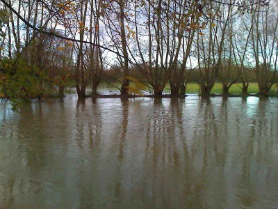
During the recent heavy rain water levels rose a good deal on the Bulstake Stream. A Flood Alert (the lowest degree of concern) was issued by the Environment Agency.

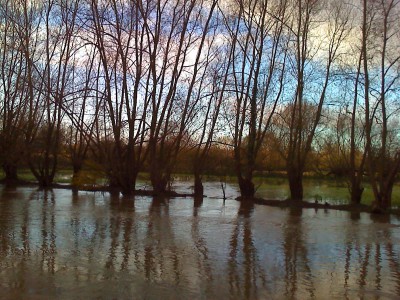
The new flood culverts under Willow Walk were filled to capacity, not with water coming off the meadow to the north, but from the channel running along the ditch on the north side of Willow Walk from the Bulstake Stream. Water also flowed into King George’s Meadow and Oatlands Road Recreation Ground at quite an alarming rate. In fact there was no control of water flows from the Thames into the Bulstake Stream at Tumbling Bay as the fixed height weir at Tumbling Bay had been over-topped. The Thames had breached the west bank upstream of Tumbling Bay (it does this very early), so this water was filling the fields and then working its way back into the Bulstake Stream by Helen Road. The Seacourt Stream was also pushing water down the Botley Stream into the Bulstake.

The Thames at Donnington was well down; the flood plain upstream from the A34 was empty and so was the flood plain above Swinford Bridge. The new sluice gate (allowing water from the Thames into Osney Stream) on the corner of North Street and East Street remained shut and certainly the Osney Stream could have taken more water.

Some questions:

What is the philosophy on how the Thames is controlled at high levels? Why was the Thames at Donnington low yet the Thames above Osney was bank high? Why was the flood plain above the A34 empty?

Should the west bank above Tumbling Bay be repaired, so stopping water getting into the flood plain at this near-property point until later, not at the beginning of an incident?

How does this last relate to the lack of control at Tumbling Bay, where there is (now) a fixed weir? If more water had been allowed to flow through Osney Lock down towards Donnington the bank at Tumbling Bay may not have been breached.

Should the new gate at North Street have been opened?

We note there is no control of water entering the Seacourt at its origin from the Thames: the weir there is now fixed (it used to have movable boards for control).

In the event, all ended well this time, the water subsiding before any properties were flooded. Our observations and questions are, nevertheless, reasonable and merit consideration by the flood risk management authorities.

Rehabilitating Ferry Hinksey ditch

22 March 2012

Work is well advanced in rehabilitating a ditch on the west edge of the Ferry Hinksey trading estate, at the east end of Willow Walk. We pointed out some time ago that this ditch had deteriorated to the extent of disappearing in places, and being completely cut off in others. Oxford City Council, led by engineer Steve Smith, designed and obtained government funding for the work. About 90% is now complete, but finishing is delayed by finding two high voltage cables that are not shown on any utility company records. Once this is sorted out the work will be completed. Well done to all concerned.

Northmoor weir

15 January 2012

We’ve just signed a petition opposing the spending of £3 MILLION to replace a perfectly good weir at Northmoor Lock, near Appleton. The flood risk reduction capital budget for Oxford is £5000 for the next 5 years.
See the background and sign the petition here http://www.ipetitions.com/petition/northmoorweir/
We’ve said this:

“If it ain’t broke don’t fix it”. To that one might add: especially when it costs £3 million, the country is experiencing economic hard times and there are many things on which (almost!) everybody would agree the money could be better spent. We are not only thinking of flood defences for Oxford, although we sorely need more and there is at present nothing in the capital budget for 2012 onwards.

1. On the so-called health and safety issue:
We believe the technical case put forward re health and safety is deeply flawed. There are serious technical objections to its conclusions. There has never been an accident.
Even were the technical a case proven (which it is not) how much should be spent in such a case? £3 million isn’t too much – apparently. How about £10 million? £20 million? What does the law require? We don’t believe it’s that stupid.
2. There is no flood risk reduction for anyone (even the EA don’t claim that there is).
3. The present weir works well and is not at the end of its life.
4. It is a beautiful and important part of our river heritage.
It’s ironic that, despite the ‘Big Society’ agenda, when ‘ordinary’ people want to be listened to it still feels like banging your head against the proverbial brick wall. We think your idea of ‘working more closely with our MP’ is an excellent approach. And the PM’s constituency is of course not far away.
This should be winnable because of the facts and the logic of the case. Get the politicians involved, as you intend, and you should succeed.
Good luck in stopping this ill-conceived waste of public money. Let us know if we can help.

Munday’s bridge, December 2011

15 December 2011

Progress after years of trying! Thames Water have a project to improve flood water drainage off the Kennington Road and this will include extensive work at Munday’s to ensure that water can then get away from the area. This is extremely good news, as Munday’s is a severe pinchpoint holding water back in the floodplain west of the railway. Thames Water hope to start work in the spring.

Thames west bank above Tumbling Bay

HELLOMOTOHELLOMOTO

The photographs show the west bank of the Thames, just north of the Botley Road, above Tumbling Bay, on 12 November 2008. Water is breaching the bank in several places. The banks are eroded further with each successive flood.

We have suggested for the last three years (now December 2011) that this bank should be repaired; however there have been difficulties in achieving this, including much debate about how much it all matters. It would seem best that the area is looked at as dispassionately as possible, and computer modelling seems a good place to start. We would like the Environment Agency to assess what impact water, escaping from the river here early on, well before flooding of properties occurs,  has on levels and flow in the Bulstake Stream, and on groundwater levels in the Botley Road area.