Our fourth Annual Public Meeting was held on 16 November 2011
We were delighted to welcome, as last year, Andrew Smith MP, County and City Councillor Susanna Pressel and City Councillor Colin Cook. A representative attended on behalf of Nicola Blackwood MP. Apologies were received from County Councillor Rodney Rose and City Councillor Oscar Van Nooijen. Last, but by no means least, about 75 members of the public came, an excellent attendance more than four years after the last flood.
The meeting began with the award of the sole OFA Flood Star of 2011 to Paul Kirkley. Paul works as an engineer for Oxford City. His professional skills, commitment, and cooperative way of working have been instrumental in turning ideas into practical flood relief projects which will help many residents escape the miseries of flooding.
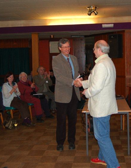
Nick Hills presents Paul Kirkley (left) with the OFA Flood Star award
A review of the year included:
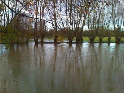
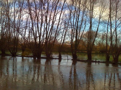
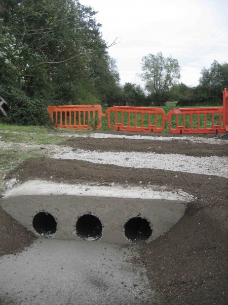
Nick Hills on the several measures now in place to protect Earl and Duke Streets, including the completion this year of the road hump at the north end of Earl Street (to be supplemented by a barrier on top during a flood) and a new route for flood water down Lamarsh Road, through Kingerlee’s land to the open meadows to the south. Nick also described the new flood culverts under Willow Walk installed this summer by the Environment Agency and originally suggested by OFA.
Andy Webber told us about the survey which he undertook of Castle Mill Stream. Following this survey the Environment Agency has cleared trees and debris from the channel at the northern end. We now await clearance under badly silted-up railway bridges, removal of sunken boats and a review of the operation of various weirs and sluices.
Paul Kirkley spoke about a possible scheme to reduce risk for residents on the east side of Duke Street, which in the process would further reduce risk for the whole Duke and Earl Street area.
Brian Durham gave an account of the problems of getting flood insurance and how a ‘DIY’ community flood risk assessment might help.
John Mastroddi told the meeting about developments at Munday’s bridge in Kennington, crucial to the drainage of the whole western flood plain. We have been campaigning about this for over four years. It now seems very likely that major improvements will be made here by Thames Water in the spring of 2012.
Richard Thurston spoke about Osney Island. Thames Water has added telemetry to the West Street Pumping station – so if their surface water pump fails, their control centre will receive immediate notification. The City Council’s scheme for property level flood protection in Bridge Street, Doyley Road and South Street (for which the funding is in place) is welcome news and should reassure many Islanders; finally, Thames Water has provided costs for the extension to the surface water drainage scheme (‘sump and pipe’) to relieve South Street and Bridge Street, but there is no funding as yet.
David Macdonald, local resident and senior hydrogeologist with the British Geological Survey, has been studying groundwater in our area for some years. He told us of a project he is leading which, if it is funded, will see Oxford have the UK’s first groundwater warning scheme, available to residents via the internet. OFA is supporting the application for funding of the scheme.
Peter Rawcliffe outlined the new central government funding arrangements for flood-related works. We discovered about three months ago that the Environment Agency had not applied for any money for Oxford under this new scheme. This came as a bombshell: so to remedy this appalling situation we have submitted suggestions to the EA for them to assess (this entails computer modelling) and then to apply the funding formula which tells one how much funding would be available. Proposals that score highly enough will be put forward for consideration by DEFRA’s Thames Regional Flood and Coastal Committee. Proposals have to be in by the summer and the EA is working to that target. We hope to be able to let you know preliminary results soon.

Andrew Smith, MP for Oxford East (above), kindly thanked OFA for their hard work and success, and offered his continuing support.