
17 June 2011

Earl Street

Bullstake Close
The City Council has obtained demountable barriers to go on top of the Earl Street road hump to keep flood water out of the street; and to keep water out of Bullstake Close.
17 June 2011
The City Council has obtained demountable barriers to go on top of the Earl Street road hump to keep flood water out of the street; and to keep water out of Bullstake Close.


3 February 2011
Work began recently to create a road and pavement hump, at the north end of Earl Street, to stop floodwater on the Botley Road pouring like a river down Earl Street. The work is now complete. We have campaigned for this for over two years. It is a big step in the right direction for residents of Earl and Duke Streets. Thanks to all concerned at County, City and EA.
21 January 2011
Preparatory work has begun. The EA are doing the work. The idea came from OFA and the City has been closely involved with the EA in the planning.


20 January 2011
This is an exciting time!
Things in the Botley Road area which we have promoted and campaigned for for a long time are coming to fruition. The works will reduce flooding of properties by surface water. They result from cooperation between various bodies, including OFA.
At the end of 2008 we suggested setting up an inter-agency working party to concentrate on the Botley Road area. This was immediately taken up by the EA and agreed by the Oxford Area Flood Partnership in January 2009. Things began to move. Oxford City came up with the suggestion of a road hump at the top of Earl Street to redirect flood water; which fitted well with our suggestion that flood water be directed down Lamarsh Road instead of Earl Street, by lowering part of Lamarsh Road. The Earl Street hump is now going in – the result of work by County, City, EA and ourselves.
Very soon we expect work to start in Lamarsh Road, to lower the far end of the road. Here, as well as those already mentioned, developer Kingerlee has played a key role. A new flood route will in due course take floodwater away through the Kingerlee site to the flood meadows beyond.
Not far away, work is starting on another OFA-initiated project: the installation of flood culverts under Willow Walk. Much of the assessment and planning has been done by Oxford City in conjunction with the EA.


20 January 2011
Work is under way to put a raised road hump across the north end of Earl Street. It can be supplemented with sandbags when necessary. This will prevent flood water running down Earl Street as it has in the past. The County is carrying out the work, but the City, the EA and OFA have been involved throughout.
16 December 2010
Oxford City and the Environment Agency have worked together towards getting new flood culverts installed here. We have now heard that work is expected to start around 10 January 2011 (weather permitting).
This should help keep flood water moving, not allowing it to build up so badly.
It is something we suggested and have pressed for for some time. Thank you EA and City.
25 November 2010
Our third Annual Public Meeting was held at the West Oxford Democrats Club, Osney Island today.
Very many thanks to the Club for once again providing us with a warm and comfortable venue – not to mention the bar!
The meeting was attended by over 80 people. We had had some concern that numbers might be down as it is now 3 years since a major Oxford flood, but thanks to Andy Webber’s efforts in distributing flyers, that did not happen. A big thank you to everyone who came out on a very cold night.
It was good to see Andrew Smith, MP for Oxford East, who represents many flooded people along the Abingdon Road and elsewhere. He had with him a copy of our Building on Success, and has asked us to keep him in the picture about things at Redbridge, which affect his constituents as well as those further west. We are delighted that he said he will support us in getting necessary flood risk reduction work done there.
Flooded people from many parts of Oxford were present as were City and County Councillors and officers from City and Environment Agency. Among them it was good to see our previous Flood Stars, Nigel Bray (EA), Susanna Pressel (City and County Councillor) as well as Mary Timbrell (resident of Duke Street).

Andrew Smith, MP for Oxford East (left) and Barry Russell, Area Flood Risk Manager, Environment Agency, at OFA’s APM.

Keith Hutchence (R) of the Environment Agency was awarded our Flood Star for 2010. He was thanked for all he has done and presented with a unique bottle of “OFA Flood Star 2010” by Andy Webber.
Presentation by the EA
We were pleased to be sharing our meeting with the EA. They have been thinking about further ways to protect the Earl and Duke Street and Marlborough Court area, in particular possible ways of keeping water out of the back of properties bordering the Bulstake Stream. Barry Russell, EA Area Flood Risk Manager, presented these ideas to the meeting and answered questions. The ideas are at an early stage and residents will be consulted further; any comments in the meantime can be made direct to the EA or via your local OFA person.
Barry told the meeting about the planned pavement hump for the Botley Road end of Earl Street, which will be topped with a row of sandbags during flooding, keeping water out of the street. The County Council will be installing this in the New Year. There are also plans to provide a removable flood barrier for the alleyway into Duke Street from the east, to stop water flowing into the street from the Bulstake Stream.
Peter Rawcliffe then spoke about:
Events and work completed in 2010
January: Network Rail remove redundant level crossing bridge at Redbridge.
March: publication and launch meeting of our Building on Success, Suggestions for medium-term measures to further reduce the risk of flooding in Oxford and the surrounding area. See list of attendees at the launch meeting here.
EA clear Hinksey Stream from North Hinksey to Redbridge.
Maintaining and developing our website.
Still in progress, but now heading for a successful conclusion:
2011: in the pipeline already:
OFA’s top 4 for action in 2011:
John Mastroddi described the issues at Munday’s and Stroud’s bridges at Redbridge. See Building on Success.
Richard Thurston spoke about two things that would help Osney Island:
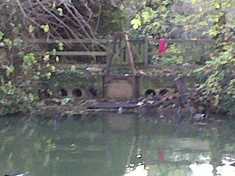
Mike Hamblett showed us the poor state of the weirs and sluices on Castle Mill Stream – the photo speaks for itself. Castle Mill Stream has potential to carry more water than it does, having relatively high gradients. We suggest these structures be mapped and listed and their condition and operation be examined, as a first step to improving them.
Mike then spoke of the broken down state of about 500 m of the west Thames bank above Tumbling Bay. See Building on Success. Water pours out of the river here when river levels are high, further damaging the bank in the process. We are concerned that this water may make flooding worse in the Botley Road area. The effect of the water leaving the river, compared to what would happen if it did not do so, should be investigated. As the breakdown worsens with each episode, one can expect that before long the entire bank over the 500m length will be affected – that situation should also be looked at. The bank could be repaired fairly easily.
Resilience and insurance
Nick Hills stressed that the time to install flood resilience measures in your house is when work is being done anyway – including of course after a flood. And that people should make sure this happens, not leave it to insurers – they tend to put back what was there before, chipboard floors and carpets included. Ask that the money be made available to you to spend as you see fit – see articles by Peter Rawcliffe and Nick Hills.
24 November 2010
On 9 November Oxford City Central & South West Area Committee agreed to reallocate the money for “public art” that Kingerlee are contributing as part of their development, to the flood relief measures that we have been advocating in Lamarsh Road instead. The suggestion to do so came from Kingerlee (see post of 15 October) and has doubled the amount of money available for flood relief from Kingerlee. The necessary work will now be done. Kingerlee will do the work themselves while they are doing their own work anyway, so overheads will be minimised. After further discussions between Kingerlee, the City and the County, Kingerlee have instructed their engineers to prepare a scheme and hope to start work early in the New Year.
THESE ARE THE (ALMOST) FINAL DEVELOPMENTS IN A CAMPAIGN WHICH HAS OCCUPIED MUCH OF OUR EFFORT FOR THE PAST YEAR AND MORE. THE OUTCOME IS SUCCESS. Many other people, from City, County and the Environment Agency, and of course Kingerlee, have also worked very hard to achieve this result. MP Nicola Blackwood has been interested and supportive.
8 November 2010
Peter Rawcliffe, representing the Oxford Flood Alliance, met with David Jordan, national Director of Operations at the Environment Agency, John Russon, Head of Operations, Howard Davidson, Regional Director, and Matt Carter and Barry Russell from the local EA area, on a recent visit to Oxford. We were pleased to have such an opportunity.
A wide-ranging discussion included:
A presentation by OFA emphasising the crucial importance of improving things at Munday’s underbridge in north Kennington.
How community flood groups form and become involved (‘the Big Society’) in working with the EA on flooding. The difficulties of establishing such engagement where it does not already exist.
Attitude to risk and particularly how it relates to the Big Scheme (OFRMS) for Oxford. OFA said there was public scepticism about whether the Big Scheme would ever happen and that people would like things done now to remedy obvious deficiencies, making the most of what already exists, even though they together fall short of a 1 in 100 year standard of protection (as is inevitable).
Once such remedial measures were taken, then incremental improvements to existing watercourses, particularly widening Hinksey Stream, working up the floodplain, might be a sensible approach, rather than relying on a possible new grand Western Conveyance which might very well never materialise.
Having said all that, information gathered for the Big Scheme can inform decisions in the meantime and if climate change makes things worse it might then be implemented. We suggested that improvements now should not be put off for fear of jeopardising the value for money of the Big Scheme – because of the very real and widespread doubt as to it ever materialising (even were no improvements made in the meantime).
27 October 2010
Annual Public Meeting of the Oxford Area Flood Partnership (OAFP). (This is not OFA.)
We attended and asked about:
